|
Books by
Jeffery Robenalt
|
|
| Civil
War battles fought in the American Southwest cannot be measured against
the savage struggles that raged in the East where tens of thousands
of Union and Confederate soldiers clashed and died. Compared to the
epic battles in the East, the little-known clashes in the deserts
and mountains of the Southwest were nothing more than a series of
small skirmishes. Opposing forces rarely numbered more than two thousand,
and usually no more than a few hundred engaged in the fighting at
one time. However, large or small, the size of the battles meant little
to the men on both sides who were wounded, killed or captured fighting
for their beliefs. |
|
|
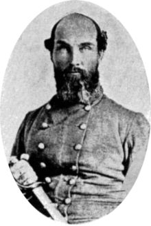
Colonel
John R. Baylor
Wikimedia Commons |
|
In early 1861,
Colonel John R. Baylor was placed in command of the Second Texas
Rifles and the western Texas frontier from Fort
Worth in the north to the Nueces River south of San
Antonio. Baylor, a former Texas rancher, farmer and slave owner,
was ordered to occupy the chain of former U.S. Army posts that ran
along the frontier and guard the route of communications to El
Paso from raids by the Apaches and Comanches. However, Baylor
was not content to sit out the war fighting Indians. The Colonel
had his sights set on the conquest of New Mexico and Arizona. On
February 14, Confederate President Jefferson Davis made Baylor�s
vision possible by ordering the occupation of the western territories.
Colonel Baylor began his western campaign by planning an attack
on Fort Fillmore near Mesilla, New Mexico with 260 troops, but the
fort�s Union commander Major Isaac Lynde was warned of the impending
strike and Baylor decided to occupy Mesilla instead. Major Lynde
then marched on Mesilla with 360 men and demanded that the Confederates
surrender. Following a series of sharp skirmishes and raids, the
Union troops were forced to retreat to the northeast toward Fort
Stanton. Colonel Baylor pursued and eventually rounded up 100 Union
stragglers, returning to Mesilla with much needed captured Union
supplies and $9,000 in Federal Treasury notes.
On August 1, 1861, Colonel Baylor issued a proclamation establishing
the Confederate Territory of Arizona, which included the former
U.S. Territories of Arizona and New Mexico south of the 34th parallel,
and declared himself governor. The new governor realized that he
would have to occupy Arizona to make the proclamation stick, so
he marched his men west. When the Confederates reached Tucson the
union forces retreated in disarray and Baylor quickly established
a Confederate government. The cross-country Butterfield stagecoach
route that ran through Texas to Arizona
and on to California was now firmly in the hands of the Confederacy,
forcing the Federal government to move the route further north through
Nebraska and Utah. The strong Union forces that remained in northern
New Mexico would be left to General Henry Hopkins Sibley.
|
|
|
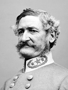
General
Henry Hopkins Sibley
Wikimedia Commons |
| Prior to the
war, Sibley served as a major in the Union Army. Like Baylor, he also
had a vision of invading the West, so he traveled to Richmond. In
the capital, Sibley argued that the Union had withdrawn from southern
New Mexico and that the northern part of the territory was ripe for
invasion. If he moved quickly north with a brigade of troops�approximately
2,500 men�he could take control of Santa Fe and the valley of the
Rio Grande, move into Colorado along the Santa Fe Trail, capture Denver
and the gold fields and then march west to California. President Davis
agreed and commissioned Sibley a brigadier general but he was on his
own. The Confederate government could not supply him with money, supplies
or troops. Undaunted, General Sibley returned to Texas where he began
to raise the Confederate Army of New Mexico. |
|
|
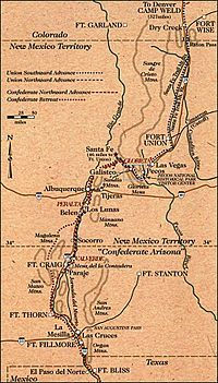
Map
Of Sibley's New Mexico Campaign
Wikimedia Commons |
| After issuing
a proclamation claiming New Mexico for the Confederacy, General Sibley
advanced north from Fort Thom in February 1862 with 2,590 ill-equipped
troops. His intentions were to follow the valley of the Rio Grande,
capturing Fort Craig, Santa Fe and Fort Union as he marched north.
Sibley�s forces neared Fort Craig on February 13. Within the fort�s
walls were nearly 3,800 men commanded by Colonel Edward Canby. Unsure
of the size of the Confederate force, Canby used wooden �Quaker guns�
to make Fort Craig appear stronger than it actually was. Falling for
the ruse, General Sibley judged the position too strong to be taken
by direct assault. Instead of attacking, he deployed his men south
of the fort, hoping to entice Canby into launching his own attack.
The Confederates remained in place for three days, but Canby refused
to take the bait. |
|
|
Colonel
Edward Canby
Wikimedia Commons |
|
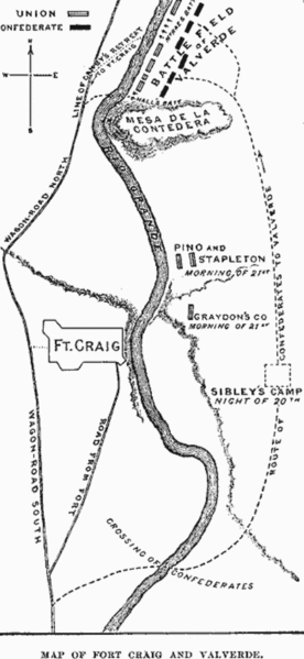
Growing short
of supplies, Sibley called for a council of war on February 18.
A decision was made to bypass Fort Craig by retreating seven miles
south to the village of Paraje and crossing to the east bank of
the Rio Grande. Sibley would then move his forces north six miles
past the fort and sever Canby�s lines of supply and communication
by capturing the ford at Valverde. Unfortunately, the deep sand
forced Sibley�s men to make an early dry camp and Union scouts took
note of their movement. Canby immediately dispatched a mixed force
of infantry, cavalry and artillery to the Valverde ford under the
command of Lieutenant Colonel Benjamin Roberts. Slowed by the movement
of his guns, Roberts ordered Major Thomas Duncan to ride ahead with
his Union cavalry and occupy the ford. Meanwhile at daybreak, General
Sibley sent Major Charles Pryon to scout the ford with four companies
of the 2nd Texas Mounted Rifles supported by Major Henry R. Raguet
with five companies of the 4th Mounted Rifles.
Reaching a small grove of cottonwoods near the ford, Pryon�s men
dismounted and began to water their horses when they discovered
that the ford was occupied by Union cavalry. A hotly contested firefight
erupted as the Confederates fell back and took cover in a dry riverbed,
and Pryon called for aid from the remainder of Scurry�s 4th Regiment.
By this time, Lieutenant Colonel Roberts reached the ford, moved
his Federal artillery into place on the west bank and advanced with
his cavalry in a loose skirmish line. Although he possessed superior
numbers, Roberts did not press the attack home. Arriving on the
scene, Colonel Scurry moved the 4th Regiment into the line on Pryon�s
right. Scurry�s Confederates were brought under fire by Union rifleman,
but the southerners were largely armed with revolvers and shotguns
which lacked sufficient range to respond in kind.
Learning of the standoff, Colonel Canby left only a skeleton force
to defend Fort Craig and advanced toward the Valverde ford with
the remainder of his Union forces. When he reached the ford, Canby
left two regiments of infantry on the west bank and pushed the rest
of his men across the river. The Federal artillery under the command
of Captain Alexander McRae continued to pound the Confederate positions
as the Union forces slowly began to gain the upper hand on the field.
Aware of the plight of his men on the river, Sibley reinforced his
position with Colonel Tom Greene�s 5th Mounted Texas Rifles and
elements of the 7th Mounted Texas Rifles. Meanwhile, either ill,
exhausted or drunk, Sibley retired to a field ambulance in the rear
and turned over the command to Colonel Greene.
|
 |
Map Of Valverde
Battlefield
Wikimedia Commons |
Early in the
afternoon, Greene authorized an attack on the Union right by a company
of the 5th Texas Mounted Rifles armed only with lances. Company B
commanded by Captain Willis L. Lang launched their gallant attack
against a company of Colorado volunteers that had been hastily recruited
and hurried south from Denver. The volunteers coolly held their fire
until the courageous lancers were within a few yards of their line
then unleashed a deadly volley into the charging Confederates. Men
and horses died in screams of pain as a wall of hot lead shattered
the lancers� advance. Company B suffered a greater loss of life than
any other company in the Army of New Mexico.
Shortly after three in the afternoon Colonel Canby arrived on the
battlefield. After assessing the situation, he decided to try and
force the Confederate left flank. He began by ordering Colonel �Kit�
Carson�s green and untested New Mexico brigade to cross the river
and move to an advanced position supported by Captain McRae�s artillery
battery. Seeing Carson forming his Federal troops for an assault,
Colonel Greene ordered Major Raguet and two companies of the Confederate
4th Regiment to launch an attack against the New Mexicans to buy some
time. Raguet�s few men were repulsed, and Carson�s New Mexico brigade
began to advance. Greene then ordered Colonel Scurry and the remainder
of his 4th Regiment to assault the Union center. Screaming their Rebel
yell, Scurry�s men surged forward in three waves, striking the Federal
line near McRae�s battery. |
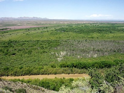 |
Looking NW across
the Rio Grande
from the Confederate battle line at Valverde
Wikimedia Commons |
The Union artillery
battery poured round-after-round of deadly grapeshot into the ranks
of the charging Texans, but Scurry�s Confederates bravely fought their
way through the hail of lead and fell on the Federal artillerymen
with a terrible hand-to hand savagery rarely seen in the annuls of
American history. Within a few minutes, the Texans had overrun the
Union guns and McRae and half his men lay dead. The Union troops fled
for the Rio Grande, many throwing their weapons down as they ran.
A number of them were gunned down by the Confederates as they floundered
across the river and headed for the safety of Fort Craig. The Union
suffered 222 killed and wounded while the Confederates lost 183. Although
the Battle of Valverde was a victory for the South, Fort Craig remained
firmly in Federal hands.
Badly in need of supplies, Sibley�s forces bypassed Fort Craig and
began a slow march up the Rio Grande, taking possession of Albuquerque
on March 2, 1862. The Federal forces left the territorial capital
of Santa Fe unprotected, and Major Pyron and his 2nd Texas Mounted
Rifles hoisted the Confederate flag over the Palace of the Governors
on March 13. As low as the Confederates were on supplies, Sibley knew
his men could not remain idle for long, and he decided to march on
Fort Union. Located on the Santa Fe Trail some 100 miles northeast
of Santa Fe, Fort Union was the main Federal supply depot and arsenal
in the southwest. Between Santa Fe and Fort Union lay the narrow confines
of Glorieta Pass.
Meanwhile, the First Regiment of Colorado Volunteers under the command
of Colonel John P. Slough made a 400 mile, thirteen-day forced march
south from Denver to reinforce the Federal garrison at Fort Union.
Upon their arrival, Colonel Slough merged his 950 Colorado volunteers
with the 800 regulars and volunteers already at the fort and assumed
command of all the troops. On March 22, Slough marched out of Fort
Union with 1300 men, most of them Colorado volunteers. Two days later
his force was camped at Bernal Springs about forty miles east of Glorieta
Pass. |
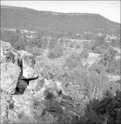 |
Glorieta Pass
Wikimedia Commons |
Unaware that
the garrison at Fort Union had been reinforced, General Sibley ordered
Major Pyron�s 2nd Regiment of Texas Mounted Rifles and four companies
of the 5th Mounted Rifles under Major Shropshire to proceed to Fort
Union. The 4th Mounted Regiment under Colonel Scurry and the First
Battalion of the 7th were ordered to ride by way of Galisteo and join
up with Pyron on the road to Fort Union. On March 25, Pyron�s forces
reached the west entrance to Glorieta Pass and set up camp at Johnson�s
Ranch. Late in the afternoon of the same day, Union Major John Chivington
marched 35 miles west from Bernal Springs with 400 men and set up
a midnight camp at Kozlowski�s ranch near the east entrance to Glorieta
Pass.
Chivington advanced his forces early on March 26 and ran into some
Confederate pickets around 2:00 pm. To the rear of the pickets, Pyron�s
main force was set up across the floor of the pass with their artillery
in the center. Chivington ordered an advance on the Confederate position,
but the fury of Pyron�s guns drove the federal infantrymen back. After
falling back to regroup, Chivington split his forces, sending them
onto the heights on both sides of the pass where they caught the Confederates
in a deadly crossfire, forcing them to retire. Pyron quickly retreated
to a narrow section of Glorieta Pass and formed a new defensive line.
Once again the Federals flanked the confederate line and punished
the rebels with a deadly hail of enfilade fire until they were forced
to withdraw.
A last minute charge from Chivington�s cavalry captured a few of the
Confederate rear guard, but with darkness coming on, the Federals
returned to Kozlowski�s ranch and set up camp for the night. Estimates
of casualties ranged from 132 to 223 for the Confederates and from
21 to 32 for the Union. No fighting occurred the following day, March
27. Instead, both sides used the day to bury their dead, tend the
wounded and consolidate their forces. Pigeon�s ranch was used as a
Union field hospital. Colonel Slough arrived at Kozlowski�s ranch
with 900 men after a forced march from Bernal, swelling the Union
ranks to around 1,300, and Colonel Scurry joined up with Major Pyron�s
forces at Johnson�s ranch, taking command of approximately 1,100 Confederate
troops. |
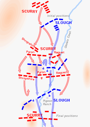 |
Map of the Glorieta
Pass Battlefield
Wikimedia
Commons |
|
On the morning
of March 28, Colonel Scurry advanced his Confederate forces into
the western reaches of Glorieta Pass and launched an attack on the
Federals. Here Scurry made a fateful decision. Believing that his
supply train would impede the advance, he left it behind at Apache
Canyon with only a small guard. Scurry halted his advance a mile
west of Pigeon�s ranch and formed a line of battle. Union scouts
informed Colonel Slough of the Confederate movement and he quickly
formulated his plans. Major Chivington and 430 men would secretly
cross over Glorieta Mesa and harass the Confederates from the rear,
while Slough and the remainder of the Federal troops advanced on
the enemy. The Federals arrived in the vicinity of Pigeon�s ranch
about 10:30 am where they broke ranks, filled their canteens and
rested.
While the men rested, Colonel Slough sent his scouts ahead to reconnoiter
the pass, but they galloped back a few minutes later with news that
the Confederates were deployed for battle in the trees no more than
800 yards distant. Confederate artillery rounds began to fall in
among the Federals as they quickly formed to meet the threat. For
the next six hours, fighting raged among the rocks and trees of
the narrow pass. The rugged terrain did not permit the use of cavalry,
but dismounted small arms and rifle fire was deadly for both sides.
The battle was close fought, but the Texans had a superior position
and a greater number of men, and eventually the Union was forced
to grudgingly give ground. Colonel Slough ordered the Federals to
fall back 400 yards near Pigeon�s ranch and form a new line across
the valley.
|
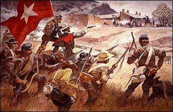 |
Painting of the
Battle of Glorieta Pass by Roy Andersen
Courtesy
Pecos National Historic Park |
|
Once again Scurry
gave the order to advance, and the fighting raged for another three
hours. After two of their three guns were knocked out and most of
the artillerymen picked off by Yankee sharpshooters, the Confederates
were forced to rely on their superior numbers to carry the day.
Eventually, they gained control of Sharpshooter�s Ridge, a key position
that enabled the Confederate riflemen to suppress the Federal guns.
Hoping to capture the Union supply train, Colonel Scurry called
for one last charge, but the Confederates were again driven back
by the fury of the Union defense. By 5:00 pm, both sides were exhausted
from the day-long, bitter fight, and Colonel Slough ordered the
Federal troops to gradually withdraw to the camp at Kozlowski�s
ranch.
The Confederates cheered when they realized the Federal withdrawal
left them holding the field, but the celebration was short-lived
when news arrived that their supply train at Apache Canyon had been
completely destroyed. Undetected, Major Chivington�s men had reached
the heights on the western end of Glorieta Pass overlooking the
canyon 1000 feet below. The federal troops slid, crawled and were
lowered by ropes to the base of the cliff from where they launched
a surprise attack on the small Confederate guard. The heavily laden
Confederate supply wagons were destroyed and the horses and mules
either killed or driven off. Chivington and his men immediately
returned to Kozlowski�s ranch to support Colonel Slough, but Scurry
requested a cease fire when he learned of the destruction of the
Confederate supply train.
|
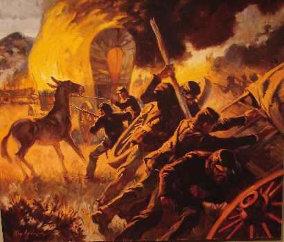 |
Burning Of Wagon
Train at Apache Canyon
Paintng by Roy Andersen
Courtesy Pecos National Historic Park |
|
The following
day was spent burying the dead and tending the wounded. This time
the Confederates used Pigeon�s ranch as a field hospital. Casualty
figures vary, but the Union suffered roughly 38 killed, 64 wounded
and 20 captured, while the Confederates had 36 dead, 60 wounded
and 25 captured. Two days later, the Texans retreated to Santa Fe.
General Sibley attempted to save the campaign by writing to the
Governor of Texas for reinforcements and supplies but he received
no reply. With no aid in sight, the Texans were forced to retreat
to southern New Mexico and eventually begin a long, starving march
back to San Antonio.
By July 1862, all Confederate troops had been withdrawn from Arizona
and New Mexico Territories and for the duration of the Civil War
the Southwest remained under Union control.
|
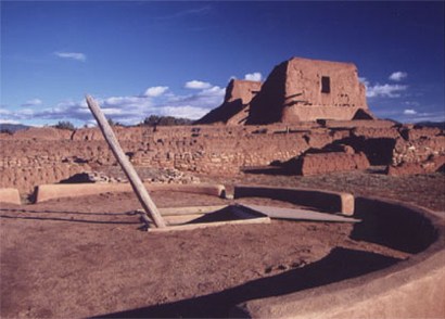
Pecos Pueblo
Mission Church
Photo
courtesy Nation Park Service |
|
Lovers of history
may view many of the sites of the Battle of Glorieta Pass by visiting
the Pecos National Historical Park. The park is located about 17
miles east of Santa Fe, New Mexico and is composed of several noncontiguous
units. The main unit of the park preserves the ruins of Pecos Pueblo
a National Historic Landmark. Francisco Coronado visited the site
in 1540 during his infamous search for the Seven Cities of Gold
and a Spanish mission was established there in 1619. Other units
of the park preserve Glorieta Pass battlefield sites including Johnson�s
Ranch, Pigeon�s Ranch, Apache Canyon and Kozlowski�s stage coach
stop on the Santa Fe Trail, as well as a stretch of wagon ruts that
run along the path of the historic trail. Park officials request
that you stop at the Visitor Center before touring the sites.
© Jeffery
Robenalt
"A Glimpse of Texas Past"
March
3, 2013 Column
jeffrobenalt@yahoo.com
|
References
for "Civil War in the Southwest"
|
|
Alberts, Don
E., Rebels on the Rio Grande: The Civil War Journal of A. B.
Peticolas, Albuquerque, NM: University of New Mexico Press (1984).
Frazier, Donald
S., Blood & Treasure: Confederate Empire in the Southwest,
College Station, TX: Texas A&M University Press (1995).
Hall, Martin
H., Sibley�s New Mexico Campaign, Austin, TX: University
of Texas Press (1960).
Josephy Jr.,
Alvin M., The Civil War in the American West, New York, NY:
Alfred A. Knopf (1991).
Kerby, Robert
L., The Confederate Invasion of New Mexico and Arizona, 1861-1862,
Tucson, AZ: Westernlore Press (1958, 1995).
Taylor, John,
Bloody Valverde: A Civil War Battle on the Rio Grande, February
21, 1862, Albuquerque, NM: University of New Mexico press (1995).
Whitlock, Flint,
Distant Bugles, Distant Drums: The Union Response to the Confederate
Invasion of New Mexico, Boulder, CO: University Press of Colorado
(2006).
|
|
|