|
|
Texas
| Trips | Lakes
DAM FUN
Highland Lakes Dams
DAMS:
Tom Miller Dam, Mansfield Dam, Max Starke Dam, Wirtz Dam, Inks Dam
and Buchanan Dam
LAKES: Lake Austin, Lake Travis, Lake
Marble Falls, Lake LBJ, Inks lake, and Lake Buchanan
An Independence
Day Trip that can be made Year-round
Just don�t expect the spectacular waterfalls shown here.
Photos and Story by Rob
Hafernik |
 |
It's
the Fourth of July, Independence Day. It's raining outside and all
of Texas is soggy and slick with what seems like months of continuous
rain. So, what to do? Take a road trip, of course!
One result of all the rain has been the amazing level of the "Highland
Lakes". These are a series of six (depending on how you count it)
lakes along the Colorado River in Texas. The final lake is Town Lake,
which is just a wide spot in the Colorado that runs through downtown
Austin. It's nice to have
a lake in the middle of town, by the way. If your town doesn't have
one, you should look into picking one up.
The
Highland Lakes are run by the Lower Colorado River Authority, which
was created in 1934 by the Texas Legislature (after much wrangling).
They coordinate the dams, manage the resources, run the parks, generate
and distribute electricity and generally take care of everything water-related
in their jurisdiction. I need to research the history of the organization,
however. It was modeled after the Tennessee Valley Authority, a gem
in FDR's New Deal crown. The first dam built, Buchanan
Dam, was started by the famous Insull Holding Company, but was
unfinished when that company went bankrupt during the Great Depression.
The LCRA was formed to finish the dam they started. It would be interesting
to know more about this. A lot of the utility companies that went
bankrupt at this time did so as a result of prodding by FDR and the
New Deal. The Wikipedia article mentions that Insull was the enemy
of Harold L. Ickes and thus had a powerful foe in the Roosevelt administration,
but doesn't mention if his empire collapsed naturally or was helped
along. It would also be nice if someone, somewhere, remembered the
thousands of families that the various lakes displaced. They also
served who packed and left. The TVA was certainly harmful, in its
day, to the nascent electricity industry, I don't know if the LCRA
was or not.
Certainly, there is no arguing that the lakes and dams built and managed
by the LCRA weren't desperately needed. The Colorado is a wild beast
that will flood at the drop of a hat and cities built along it were
regularly wiped out before the dams were built. Our situation here
in July of 2007 is a good example: without those dams, Austin
and points south would have had severe, expensive floods. Even so,
these storms have the system pushed right to its limit, with each
lake full and each dam with floodgates open.
This almost never happens. It has been fifty years since all of the
Highland Lakes were at flood stage at the same time. Two of the lakes
are huge (Travis and Buchanan) and it really takes a lot of rain to
fill them up. Since this almost never happens, my wife and I decided
to pack up the dog and do a road trip right up the chain of highland
lakes to get a first-hand look at all that water moving about. It
turned out to be a long trip, about 187 miles worth, but it was great
fun. |
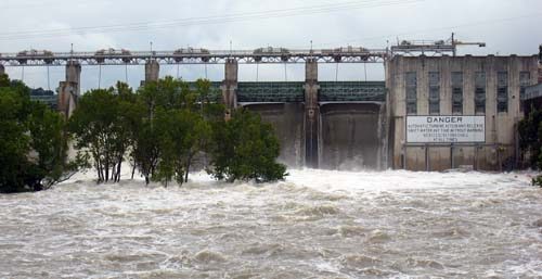
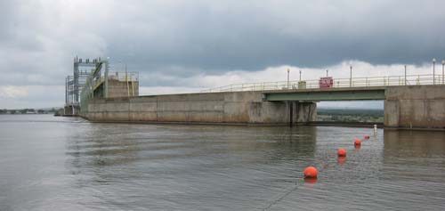
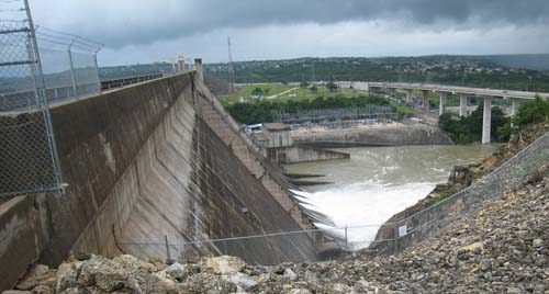
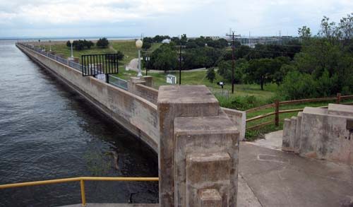
Tom
Miller Dam - Lake Austin
|
| Our
first stop, however was only a mile or so from the house: Tom Miller
Dam. Tom Miller was the mayor of Austin
when the dam was completed, so they named it after him. Two dams had
been previously constructed on the spot and both had been washed away,
with catastrophic consequences. The first time, in 1900, the dam was
a masonry dam (built of granite blocks) and about half of it washed
away. The second dam was hollow and used wooden gates. It was damaged
in 1915 and several more times in the 1930's until the city finally
built Tom Miller dam, which stands to this day (although with some
upgrades). |
| Tom Miller Dam
- with three and half floodgates open |
So, that's what
26,000 cubic feet per second of water looks like. It's impressive;
it's loud. Town lake is flowing briskly, with water about 4-5 feet
higher than normal. If you check Google Maps, you see an island just
south of the dam, called Red Bud Isle. It was created, in part, by
the debris of the masonry dam that was swept away in 1900. All over
the island (it's an off-lead dog park, now) you see big granite blocks
heaped about.
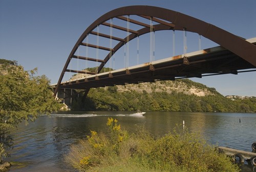
Above the dam is Lake
Austin, a constant level lake with many, many expensive homes
and boats. It holds about 21,000 acre-feet of water and, when it's
flowing the way it is right now, pushes enough water through Tom Miller
Dam to generate 17 megawatts of electricity. It's also home to the
Pennybacker
Bridge, which is a sort of Austin
icon (although everyone just calls it the "Loop 360 Bridge"). |
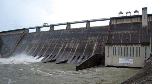
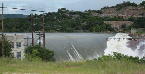
Mansfield
Dam - Lake Travis
|
| Next,
we drove out Hwy 71 to 620 and over to Mansfield Dam. |
| Mansfield Dam
- with three and half floodgates open |
Mansfield Dam
was built between 1937 and 1941, when severe floods had shown that
a flood-control dam was a necessity along this part of the Colorado.
It was named after our congressman of the time, J.J. Mansfield, who
probably wangled lots of federal money for the project. It's a much
large dam than Tom Miller dam, the difference in elevation between
the lake and the outflow is nearly 200 feet. This allows it to generate
up to 102 megawatts of electricity.
Lake Travis is created by Mansfield Dam and it is a whopper
(well, not compared to Lake Michigan, I suppose, but you know what
I mean). When full, it covers 18,622 acres (almost 30 square miles)
with 369 billion gallons of water (or 1,131,650 acre-feet). But it's
20 feet above that now, which adds another 375,000 or so acre-feet,
for a total close to 1.5 million acre-feet of water (nearly 500 billion
gallons). With our state-mandated 1.6 gallon-per-flush toilets, that's
enough for over 300 billion flushes. That's one flush per person in
Austin every day for over
a thousand years. Yet, at today's flow of 26,000 cubic feet per second,
the lake could be filled up in only 30 days or so, which goes to show
you how much rain we've had lately in central Texas. |
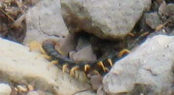 |
| While we were
standing in the crowd of people taking pictures of the outflow (yes,
there are lots of other people as geeky as us, we saw people taking
pictures at each of the dams), this big centipede was crawling over
the rocks just inside of the fence. It was about four inches long,
ugly and lucky to be safely on the other side of the fence. All of
those legs allowed it to move quite quickly over the ground; it covered
several feet in the few seconds I was watching it. And, yes, Google
has it: this is a Giant Dessert Centipede, Scolopendra heros.
They can evidently get up to six inches long and they kill with venom.
Their jaws are strong enough to inject venom in humans, so I would
advise against handling them. |
Next,
it was back to Hwy 71, up to Hwt 281 and in to Marble
Falls. The next dam up the river is Max Starcke Dam and
here we were disappointed. The road that leads out to the dam was
closed with a sign saying, "authorized personnel only". There is only
the one road, too. The dam is quite inaccessible, especially from
the downstream side.
If you check out Google Maps, you'll see that the dam is downstream
of downtown Marble
Falls, in the middle of absolutely nowhere. The land on the north
side of the river is completely uninhabited. Lake
Marble Falls is only 611 acres when full, just barely worth
the trouble, it seems to me. The dam was built to generate electricity
and is capable of producing 32 megawatts. Max Starcke, by the way,
was the second General Manager of LCRA. |
 |
| This
was one full dam. You can see that the water is within a couple of
feet of spilling out on its own. Floodgates were open and you could
see a sort of deadly-looking whirlpool over near the face of the dam
where the water was being sucked out. Wirtz Dam forms Lake
LBJ, which is a respectable 6,534 acres when full. Interestingly,
both the dam and lake were originally named "Granite Shoals," but
the dam was renamed in 1952 for Alvin J. Wirtz, who was the first
general counsel of the LCRA and helped to get the federal grants that
formed the initial LCRA. The lake was renamed after the president
in 1965. The dam was also built primarily for hydroelectric generation
and produces 56 megawatts when going full out. |
 |
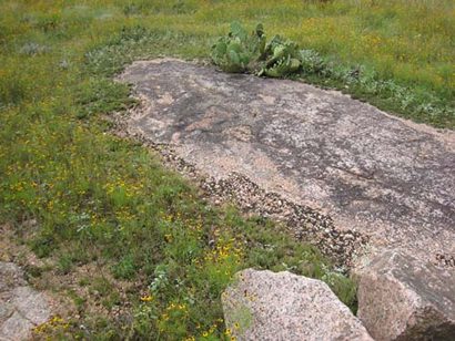
| The shoreline
of Lake LBJ is made up of granite gravel. I don't know if this formed
naturally, or if they intentionally created a beach out of the stuff.
At least they used local materials. Lake LBJ is also home to a large,
exclusive resort: Horseshoe Bay. This is a lovely resort area, with
some nice golf courses � or so I'm told. The lake also produces cooling
water for a nearby power plant, but I couldn't find any details about
that. I found the plant here on Google Maps, but it isn't named. It
looks like a natural gas plant, but I only say that because of the
storage tanks nearby and the lack of railroad for coal delivery. |
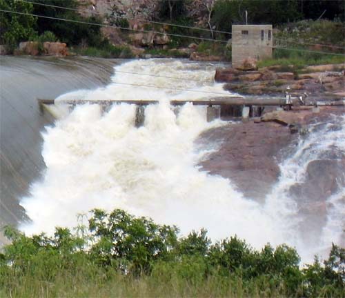
| From
here, we drove north on FM 1431, through the odd little town of Kingsland
(where we stopped an bought some produce from a little roadside stand),
to Inks Dam. I had to stop and get a map of the local area,
because I had never been to Inks dam before. Indeed, it's another
dam that is out in the middle of nowhere. After a couple of small
county roads and some directions at the office of a trailer park (Inks
Dam Road is unmarked, it turns out), we found the right little one-lane
road that took us to the overlook of Inks dam. It was the most impressive
sight so far: |
| Inks dam doesn't
have flood gates, just a spillway. And was it spilling! According
to the LCRA, the water was five feet over the dam. They had closed
off all areas that provided a closer look (and I'm not sure how close
I wanted to get, anyway), but you could still hear the massive roar
at a distance. |
| Close up view
of Inks Dam spillway |
| That is some
kind of angry water. Inks Lake is only 837 acres when full
and the dam, finished in 1938, only generates 14 megawatts. It was
named for Roy B. Inks, one of the founding board members of the LCRA.
That pattern should be clear by now: all of the dams and lakes are
named after politicians who secured the funds or big shots at the
LCRA. No local heros or geographic features made the list. Inks lake
is also a "constant level" lake, since it can't fill up any higher
than the spillway. It's remote enough and small enough that it has
never become the playground of the rich, as Lake LBJ and Travis have.
There are some nice campgrounds and cabins around for average folk,
though, and lots of RV parks. |
| Next
up the chain we have Buchanan Dam. It's only a couple of miles
from Inks Dam, but it's quite a lot larger. Hell, the thing is nearly
two miles long: |
 |
If you zoom in
on the south part of the dam, you can see that part of it is a series
of horizontal arches. It's evidently the largest multiple arch dam
in the country. Considering its age, I suspect this means that they've
found better ways to build dams than using horizontal arches. It certainly
stands out on Google Maps. The lake and dam are named after U.S. Rep.
J.P. Buchanan, who secured the funding for the LCRA. I like the art
deco detail work in the concrete and fixtures. It still looks sharp
after 70 years.
The floodgates were open here, too, but they were too far in the distance
to see. Later, from Hwy 29, we were able to get a glimpse of enormous
amounts of white foam pouring out, but I was driving and couldn't
get a picture. It was too far away for a good picture anyway. Lake
Buchanan is the second largest of the Highland Lakes, at 22.335
acres. It holds 285 billion gallons of water when full and was a few
feet over full when we visited. It can generate 51 megawatts of electricity
when the lake is up. |
 |
| So,
that's it. The rest of the Colorado snakes up into west Texas. The
LCRA has this to say about the naming of the Colorado River: |
| "Colorado" is
Spanish for "red" � an odd name for a river that early Spanish explorers
noted had such clear water. Historians speculate the explorers intended
to name the river "Brazos de Dios" (Arms of God), perhaps because
of its tributaries in its watershed. But mapmakers switched its name
with the adjacent Brazos River basin, perhaps because of a clerical
error. |
Well, maybe.
It's also possible, in my humble, non-historian opinion, that all
of that red granite had something to do with it as well. The water
could easily look red in the areas where it has cut down through
the pink granite. I guess we'll never know.
We saw lots
of other people on our trip. Even at hard-to-reach Inks dam, there
were a few other hardy souls out to see the once-in-a-lifetime lake
levels. Our dog Ruby wasn't much impressed, however. She thought
it was the stupidest trip we've ever taken. Get in the car, get
out of the car, drive, park and repeat. All of that time and all
of those miles and we wound up back at home where we'd started.
She finally got sick of it and curled up in the farthest corner.
© Rob Hafernik
(About
Rob Hafernick, and his website)
|
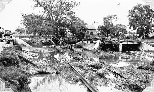
| D'Hanis after
the 1935 Flood |
| Texas
Escapes, in its purpose to preserve historic, endangered
and vanishing Texas, asks that anyone wishing to share their local
history and vintage/historic photos, please contact
us. |
|
|