|
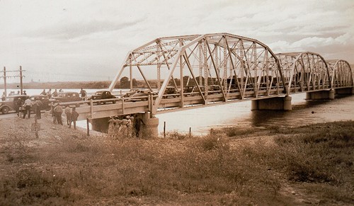
Opening Day
for the Montopolis Bridge over the Colorado River
(On the National Register of Historic Places)
Photo
Courtesy TXDoT
More Texas
Bridges |
Montopolis,
TX
Handbook of Texas
Online:
Travis
County has had two locations named Montopolis that differ in their
formation and location. The original Montopolis was a Republic
of Texas era town established by Jesse Cornelius Tannehill. Tannehill's
time in Texas preceding Montopolis is well established. He came to
Texas with his family in 1828 and first settled near Caney Creek in
Matagorda County.
By 1829 Tannehill was in Bastrop
County as a member of Stephen
F. Austin's "Little Colony." In 1836 during the Texas Revolution
the Tannehills and other families fled Bastrop as part the Runaway
Scrape. Following the war, the Tannehills lived in Huntsville
and later in La Grange
until 1839.
In 1832 while in Bastrop, Tannehill received a headright league on
the north bank of the Colorado River, east of and adjacent
to what would become Austin,
and that became the location of the Montopolis townsite. Planning
and surveying of the 800-acre townsite started in 1838, and Jesse
Tannehill moved his family to the Montopolis tract in early 1839.
George W. Bonnell, who recorded his "Observations" while traveling
through the Texas frontier in 1838, provided this description while
traveling up the Colorado: "[July 24th we then reached] the intended
scite [sic] of the new town to be called Montropolis [sic]. It is
on the east bank of the river, and tolerably pleasantly situated.
Some 15 or 20 men are now at work at this place, who expect to have
each a cabin erected in a few weeks." Three miles farther Bonnell
reported arriving at another "new town": Waterloo.
On July 2, 1839, Jesse Tannehill and five other men entered an agreement
defining their Montopolis partnership that was recorded by the Bastrop
County clerk. This document contains the earliest known plat of the
original town tract. The original Montopolis town tract was designed
with lots for homes, farming, out-lots, and churches, "Seminaries
of learning and other Public buildings�to promote the general prosperity
of the place." Streets were laid out on a grid much like Edwin Waller's
design of Austin. Indeed, evidence suggests Montopolis aspired to
become the capital of the new Republic of Texas, but Waterloo was
selected instead. Montopolis did not develop as expected, probably
because of its proximity to Austin, and by 1841 the Montopolis partnership
was dissolved, and land sold. Although the Montopolis partnership
ended, Montopolis as a community persisted; businesses such as Howard's
Montopolis Nursery at the heart of the original town tract preserved
the memory of the original Montopolis into the twentieth century.
Legal documents continued to reference the "Montopolis town tract"
into the twentieth century.
The second Montopolis is a community south of the Colorado
River on the Santiago Del Valle grant that began taking shape
in Texas's
Reconstruction era and into the early twentieth century, evolving
to become the neighborhood most Austinites recognize today as Montopolis.
In 1838 when Tannehill laid out the original town tract north of the
river, the area south of the river where the current community exists
comprised nine leagues of the Santiago Del Valle grant. It was still
virtually vacant land entirely owned by Galveston founder Michael
B. Menard who sold it to Thomas F. McKinney in February 1839. McKinney
did not begin selling portions of it until after Waterloo had been
selected as the capital. Tannehill never owned any part of the Santiago
Del Valle grant, nor was he in any way involved in development or
settlement south of the Colorado River, where the current community
of Montopolis is located. In the nineteenth century the earliest post
office that opened south of the river on the Del Valle grant was Bluff
Springs in 1853, followed by Del Valle
in 1878, Carl in 1887, and the last was the Montopolis post office
opening in January 1897 on the south bank of the river near the ferry
crossing; it was discontinued in 1902. While short-lived, the post
office, along with its location on the Montopolis ford, was the catalyst
for the adoption of the name Montopolis for the community that was
developing south of the river.
After the turn of the twentieth century citizens of the area known
today as the Montopolis neighborhood began to forge their own identity
and incorporated the name with local businesses. One of the most significant
landmarks that identifies the neighborhood was established in 1950
when seventy local residents petitioned the Travis County Commissioners
Court to rename two existing nineteenth century roads from Miller
Lane and Boothe Lane to Montopolis Drive. Most of Montopolis proper
was annexed by the city of Austin
in 1951. Additional portions of the area were annexed during the 1960s
and 1970s.
The current Montopolis community contains two cemeteries that have
been designated historic by the Texas Historical Commission—the
Burditt Prairie Cemetery that includes burials of enslaved
persons and their families and the San Jose Cemetery that was
established in the early twentieth century and reflects the strong
Mexican American influence. About 1891 a school for African American
children was established in the Colorado School District as school
No. 34. The building was destroyed in a storm in 1935. Land was then
donated by St. Edward's Baptist Church and a second school constructed.
That school became part of the Austin Independent School District
in 1952, then closed in 1962 as part of city-wide desegregation.
The common thread joining old and new Montopolis is the historic river
crossing become ferry then bridge of the same name. The name "Montopolis"
as a river ford dates to the Republic of Texas era Montopolis townsite.
The crossing is older than either of the two Montopolis communities.
Indigenous people lived in and traveled through the area for thousands
of years prior to the arrival of Europeans. Historic El Camino Real
de los Tejas, established by the Spanish along American Indian trails,
skirted the eastern edge of today's Montopolis neighborhood fording
the Colorado east of today's Montopolis Bridge. During Texas Reconstruction
the crossing was part of the Chisholm Trail. The old Montopolis bridge
is on the National Register of Historic Places.
Richard Denney and Lanny Ottosen, "Montopolis, TX,"
Handbook of Texas Online, accessed August 02, 2022, https://www.tshaonline.org/handbook/entries/montopolis-tx.
Related article:
The
Texas Flood of 1935 |
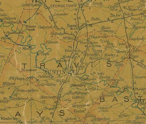 |
Travis
County 1907 postal map showing Montopolis
along the Colorado River
SE of Austin
From Texas state map #2090
Courtesy Texas General Land Office |
| Texas
Escapes, in its purpose to preserve historic, endangered and vanishing
Texas, asks that anyone wishing to share their local history, stories,
landmarks and recent or vintage photos, please contact
us. |
|
|