TexasEscapes.com HOME Welcome to Texas Escapes
A magazine written by Texas
 
New   |   Texas Towns   |   Ghost Towns   |   Counties   |   Trips   |   Features   |   Columns   |   Architecture   |   Images   |   Archives   |   Site Map

Culberson County TX
Culberson County
Van Horn Hotels

PINE SPRINGS, TEXAS

“The Windiest Town in Texas”

Culberson County, West Texas

31° 53' 37.68" N, 104° 48' 59.04" W (31.8938, -104.8164)
U.S. Highway 62/180
About 60 Miles N of Van Horn
About 3 Miles S of Guadalupe Peak
(Guadalupe Mountain National Park)
Population: 20 est. (2000)

Wild Horse, Texas Area Hotels › Van Horn Hotels
Pine Springs TX markers
Markers in Pine Springs
Photo courtesy Barclay Gibson, May 2009
History in a Pecan Shell

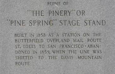
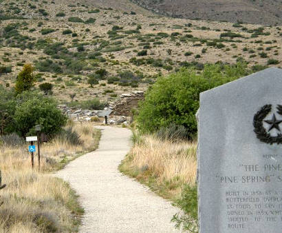
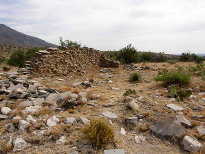
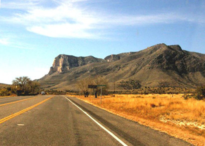
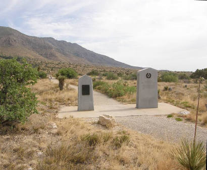
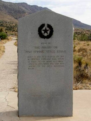
The site was well-known as stopping point for those crossing Guadalupe Pass. In 1858 it became a stop on the Butterfield Overland Stage Mail route. The company designated the stop as “The Pinery.” The stop was moved south within its first year of operation for the protection offered by Forts Davis and Stockton.

In 1870 it was used as a base for scouting expeditions against the Mescalero Apaches. After the Indian threat had vanished, the site was employed by those heading west across the mountains. A man by the name of Walter Glover bought the land in 1907 and started a ranch.

When U.S. Highway 62 was opened in 1928, Walter and Bertha Glover went into the café business to provide nourishment for motorists. After the death of Walter, Bertha remained at the helm until her death in 1982.

The population in 1942 was reportedly 50 residents which grew to 70 in the mid 1940s before falling to a mere 10 people twenty years later.

The post office closed in 1943. The Guadalupe Mountains National Park opened in 1972 with the opening, the population of Pine Springs doubled to 20 residents – the same number used for the 1990 and 200 count.


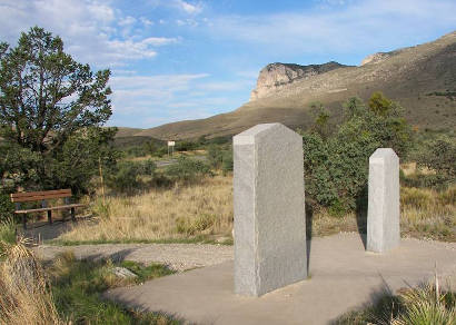
Photographer's Note:
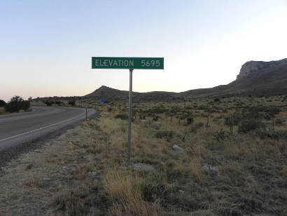
The Pine Springs Stage Stand is/was located right at the what is now the highest roadway in Texas, officially 5,695 feet. The grocery store/gas station which served the area for many years is now long gone. The new headquarters building of the Guadalupe Mountains National Park is not from the old stage stop.
Pine Springs TX Centennial Marker
Photo courtesy Barclay Gibson, May 2009
Pine Springs TX Centennial Marker text
Ruins of "The Pinery" Texas Centennial Marker
Photo courtesy Barclay Gibson, May 2009
More Texas Centennial Markers
Pine Springs TX Markers
Photo courtesy Barclay Gibson, May 2009
Pine SpringsTX - Pinery Ruins
To Pinery Ruins
Photo courtesy Barclay Gibson, May 2009
Pine SpringsTX - Pinery Ruins
The Pinery Ruins
Photo courtesy Barclay Gibson, May 2009
Pine Springs Tx - Airmen Memorial
Airmen Memorial
Photo courtesy Barclay Gibson, May 2009
Pine Springs Tx - Altitude Sign
The highest roadway in Texas
Photo courtesy Barclay Gibson, May 2009
Pine Springs Tx - Gas Up Sign
The Gas Up Warning sign in New Mexico just south of White's City.
Photo courtesy Barclay Gibson, May 2009
More Texas Signs

Guadalupe Mountains National Park

"Park information, including park conditions, closures or restrictions, weather and program information, may be found on the park’s website at www.nps.gov or by contacting the Headquarters (Pine Springs) Visitor Center at (915) 828-3251 x2124.... Motorists traveling past the park along U.S. Hwy 62/180 may tune in to the park’s Traveler Information Station at 1610 AM for up-to-date park information."
Guadalupe Peak Tx - Guadalupe Mountain National Park
Guadalupe Mountain National Park
Photo Courtesy Barclay Gibson, November 2009

Culberson County TX 1940s map
1940s Culberson County map showing Guadalupe Peak & Van Horn
From Texas state map #4335

Courtesy Texas General Land Office

Take a road trip

Pine Springs, Texas Nearby Destinations:
Guadalupe Peak
Van Horn the county seat
See Culberson County | West Texas

Book Hotel Here:
Van Horn Hotels | More Hotels
Texas Escapes, in its purpose to preserve historic, endangered and vanishing Texas, asks that anyone wishing to share their local history and vintage/historic photos, please contact us.

Texas Towns A - Z Texas Regions:
Gulf Texas Gulf Coast East East Texas North Central Texas North Central Woutn Central Texas South Panhandle Texas Panhandle
South South Texas Hill Texas Hill Country West West Texas Ghost Texas Ghost Towns counties Texas Counties

Texas Escapes Online Magazine »   Archive Issues » Go to Home Page »
TEXAS TOWNS & COUNTIES TEXAS LANDMARKS & IMAGES TEXAS HISTORY & CULTURE TEXAS OUTDOORS MORE
Texas Counties
Texas Towns A-Z
Texas Ghost Towns

TEXAS REGIONS:
Central Texas North
Central Texas South
Texas Gulf Coast
Texas Panhandle
Texas Hill Country
East Texas
South Texas
West Texas

Courthouses
Jails
Churches
Schoolhouses
Bridges
Theaters
Depots
Rooms with a Past
Monuments
Statues

Gas Stations
Post Offices
Museums
Water Towers
Grain Elevators
Cotton Gins
Lodges
Stores
Banks

Vintage Photos
Historic Trees
Cemeteries
Old Neon
Ghost Signs
Signs
Murals
Gargoyles
Pitted Dates
Cornerstones
Then & Now

Columns: History/Opinion
Texas History
Small Town Sagas
Black History
WWII
Texas Centennial
Ghosts
People
Animals
Food
Music
Art

Books
Cotton
Texas Railroads

Texas Trips
Texas Drives
Texas State Parks
Texas Rivers
Texas Lakes
Texas Forts
Texas Trails
Texas Maps
USA
MEXICO
HOTELS

Site Map
About Us
Privacy Statement
Disclaimer
Contributors
Staff
Contact Us

 
Website Content Copyright Texas Escapes LLC. All Rights Reserved