|
History on
a Pinhead
Founded along the
tracks of the Houston and Texas Central Railroad in the late 1880s,
the community once had its own post office but mail service was re-routed
through Houston and the
post office closed in 1905. (See 1907
Harris County postal map) The town peaked as a separate community
with a population of 500 but by 1915 it was considered part of Houston.
|
Brunner, TX
by Bruce Martin
Not all �Ghost Towns� are evacuated and evolve into decay. Some
are absorbed by the growth of adjacent cities.
Brunner is an area within Houston
that was at one time a distinct community. It was located in west
central Harris County, along the Houston and Texas Central Railway
and 3 miles west of Houston.
In 1895, Brunner�s population was 500 and it had a Baptist college,
a public school, a German school, two churches, and a saloon. By
1888, a post office existed. The community had 200 residents in
1894. In 1905, the post office closed and the post office in Houston
handled the community�s mail service. During that year, the community
had 402 people. By 1915, the City of Houston took over what was
Brunner and it was no longer considered a community distinct from
Houston. [Kleiner, Diana
J., �Handbook of Texas�]
|
|
|
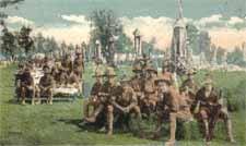
Camp
Logan in Houston
TE postcard |
Located in Houston�s
Sixth Ward, the area is directly east of the former Camp Logan, a
World War I Army Training
Camp. In August, 1917, there was a riot among black soldiers and the
local police. (Details of the event can be retrieved from the �Camp
Logan Riot� internet site.) Following the altercation, my uncle recovered
a bayonet within blocks of his residence. The Camp Logan grounds are
now within Houston�s Memorial
Park. One stretch of road, leading to the golf course, remains in
original condition. Some chunks of concrete building foundations and
extensive trenches used in training exercises still remain in the
heavily-forested park.
It is unclear whether an overlay of the Brunner area limits with current
maps would indicate its relationship with the now Houston Heights,
a region located four miles northwest of downtown Houston.
As reported in National Geographic on Foot, �stroll the area�s broad
tree-canopied esplanades and side streets dotted with homes dating
from the early 1900�s and you may think you have landed in a small
town. Residents wave cheerful greetings as they walk dogs or tend
to gardens exploding with palms, crepe myrtle trees, and trumpet vines�.
Adjacent to the south lies the area referred to as �West End�, a neighborhood
located along the Washington Avenue Corridor. Traditionally a working
class neighborhood, recent development has increased the population
density. The official boundaries of West End are Durham Drive to the
west, Washington Avenue to the south, I-10 to the north, and Yale
Street to the east. Both my paternal and maternal grandparents lived
in West End during the 1930�s.
Raymond Knipple had a shop filled with machines dating from World
War I. All of the equipment ran from ONE electric motor connected
to the various machines by shafts, pulleys, and leather belts descending
from the ceiling. To sharpen a chisel, all machines ran! In the late
1950�s, he built a stagecoach, a surrey with the fringe on top, and
a �cut-under� for the film industry, used in movies. The hardware
and disassembled pieces came from two sources: the Amish in Pennsylvania
and from Austria. The wagon wheels were handcrafted by Raymond. [Contributed
by: Thomas G. Mazzu, Houston]
West End is a part of Super Neighborhood 22, an organized collection
of neighborhood civic groups that voices their neighborhood�s interests
to various local issues and situations. North of Houston Heights is
an area referred to as �Shady Acres�.
© Bruce Martin
May 9, 2012 |
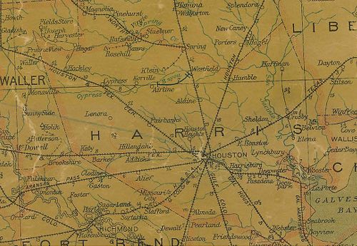 |
Harris
County 1907 Postal Map showing tracks of the HTC Railroad, but
absence of Brunner
Courtesy
Texas General Land Office |
| Texas
Escapes, in its purpose to preserve historic, endangered and vanishing
Texas, asks that anyone wishing to share their local history, stories,
landmarks and recent or vintage photos, please contact
us. |
|
|

 Texas
Gulf Coast
Texas
Gulf Coast East
Texas
East
Texas Central
Texas North
Central
Texas North Central
Texas South
Central
Texas South Texas
Panhandle
Texas
Panhandle South
Texas
South
Texas Texas
Hill Country
Texas
Hill Country West
Texas
West
Texas Texas
Ghost Towns
Texas
Ghost Towns Texas
Counties
Texas
Counties