|
HEBRON, TEXAS
Denton
County, Central
Texas North
33� 1' 42" N, 96� 53' 55" W (33.028333, -96.898611)
Intersection of FM 3040 (Hebron Parkway) and
FM 544 (West Park Boulevard)
21
miles SE of Denton
the county seat
22 miles NE of Dallas
Population: 215 Est. (2019)
415 (2010) 874 (2000) 1,128 (1990) 385 (1980)
Book Hotel Here › Denton
Hotels |
 |
HEBRON, TX
Handbook of
Texas:
"Hebron, twenty-one miles southeast of Denton
in southeast Denton
County, was founded in the vicinity of the old Bridges Settlement
of 1843. It was named for the Biblical town of Hebron. By 1890 the
community had a post office. In 1902 the Red River, Texas and Southern
(now Burlington Northern) Railway built through the town. At one time
Hebron had three cotton gins. It was incorporated briefly in the mid-1960s,
but it was not permanently incorporated until the mid-1970s. Economic
development between Dallas
and Denton spurred the population
in Hebron to 486 in 1975. In 1980 the population was 385. The aggressive
annexation policies pursued by Carrollton
and Plano placed limits on the ability
of Hebron to expand geographically. In 1990 the population was 1,128,
and in 2000 it was 874."
David Minor, �Hebron, TX (Denton County),� Handbook of Texas Online,
accessed October 12, 2023, https://www.tshaonline.org/handbook/entries/hebron-tx-denton-county.
Published by the Texas State Historical Association. |
 |
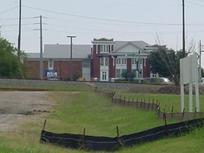
Remnants of old
township - First Street scene
Photo by Robin
Jett, 10-2004 |
HEBRON � A
Ghost Town That Isn�t
by Robin
Jett
December
11, 2004
Smack-dab in the suburban sprawl between Plano
and Carrollton
At intersection of FM 3040 (Hebron Parkway) and FM 544 (West Park
Boulevard) 22 miles northeast of Dallas
Suburban sprawl have taken over the vast prairies north of Dallas,
and nowhere is that more evident than when one wants to find the remains
of towns that have simply vanished under concrete and incorporation
aspirations. Renner in
Dallas County is a good example of one of these lost towns: today
it exists only as the name of a busy thoroughfare. Its 1888 school
graces the collection of buildings on display at Old City Park near
downtown Dallas, and that�s
pretty much all you�ll be able to find of this old farming community.
|
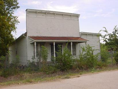
Hebron
is another lost town. The town exists, at least in theory - an impressive
beaux-arts church still graces the crossroads that mark the town,
and First Street retains some old store facades (now in disuse). But
because of the development of extreme southeastern Denton
County � Hebron lies so close to the sprawl of Plano
that if you spit, you�re liable to hit someone�s Prada shoes � the
town is nothing more than a speck in the road.
Hebron, the earliest settlement in Denton
County, came to life as an offshoot of the Peters Colony, a group
of land hungry pioneers who were the first Anglos to attempt farming
on the Grand Prairie. By 1890, Hebron had a post office, and the tracks
laid in the early 20th century are still in use today. At the height
of its township, Hebron had a population of 468. But with aggressive
suburban growth threatening it from all sides, Hebron found its growth
limited. Today its hemmed in by both Plano
and Carrollton, and due to their
sprawl, Hebron is now more populated than ever.
So, Hebron technically still exits. The street that runs through it
� FM 3040 � bears its name. The church is well attended, though a
slew of mega-churches have popped up all around it, siphoning off
at least a few parishioners. The new high school, completed in 1999
and part of the Lewisville Independent School District, is named after
the little town. On a detailed city or county map, you can even identify
Hebron�s boundaries. But the town itself, from which flowed the majority
of Anglo settlement of Denton
County, is now but a distant memory.
� Robin
Jett
December 11, 2004 |
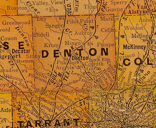 |
Denton
County 1920s map showing Hebron
in the SE near Collin
County line
From Texas state map #10749
Courtesy
Texas General Land Office |
| Texas
Escapes, in its purpose to preserve historic, endangered and vanishing
Texas, asks that anyone wishing to share Hebron history, stories,
landmarks and recent or vintage photos, please contact
us. |
|
|