|
|
| Traffic
is not a problem in Anahuac. TE Photo |
History
in a Seashell
In 1721 a French explorer named Jean Baptiste de La Harpe visited
a village of Atakapans Indians near what would become Anahuac.
Construction of a fort was begun in 1830.
Gen. Manuel de Mier y Ter�n, commanding officer of the Mexican province
of Coahuila y Texas, named the town Anahuac in 1831. The is the Aztec
word for the known world - which before the Conquest, was the Aztec
capital.
The town experienced turmoil in 1832 and 1835 before the Texas Revolution
began in earnest.
After Independence,
Gen. Thomas Jefferson Chambers and Charles Willcox both claimed ownership
of the townsite which stunted the community's growth. Chambers was
killed by an assassin in his home one night in 1865, ending the dispute.
General Chambers modestly called the town Chambersea in his
own honor - a view that wasn't popular. His house is now a local historic
site.
A
brief timeline of significant events in Anahuac's history:
1900s:
The Anahuac Townsite Company began real estate development
1902: Construction of the Lone Star
Canal began
1907: Election was held to make Anahuac county seat over Wallisville.
1935: Oil is discovered offshore
1963: National Wildlife Refuge was established 16 miles from Anahuac
|
Anahuac, Texas
Landmarks / Attractions
|
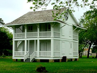
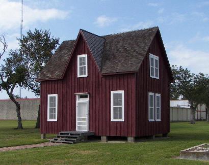
Chambersea: The
home of Thomas Jefferson Chambers
Washington Ave. and Cummings St.
Recorded Texas Historic Landmark
TE Photo, 2003 |
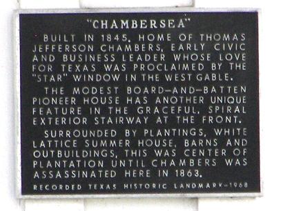
Chambersea Historical
Marker
Photo courtesy Terry
Jeanson, October 2010 |
Chambersea
Built in 1845.
Home of Thomas Jefferson Chambers, early civic and business leader
whose love for Texas was proclaimed by the "Star" window in the west
gable. The modest board-and-batten pioneer house has another unique
feature in the graceful, spiral exterior stairway at the front. Surrounded
by plantings, white lattice summer house, barns and outbuildings,
this was center of plantation until Chambers was assassinated here
in 1863.
Recorded Texas Historic Landmark - 1968 |
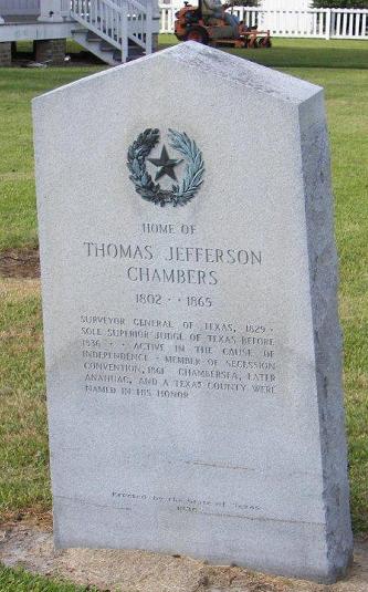
Home of Thomas
Jefferson Chambers
1802 - 1865
Surveyor general of Texas, 1829.
Sole superior judge of Texas before 1836. Active in the cause of
independence. Member of secession convention, 1861. Chambersea, later
Anahuac, and a Texas county were named in his honor.
Erected by the state of Texas
1936 |
Dr. Schilling
Medical Office
Washington Ave. and Cummings St.
Photo courtesy Terry
Jeanson, October 2010 |
Dr. Schilling
Medical Office Historical Marker
Photo courtesy Terry
Jeanson, October 2010 |
Historical Marker
- Washington Ave. and Cummings St.
The Dr.
N. T. Schilling Medical Office
Nicholas T. Schilling,
born in Bavaria on Nov. 28, 1845, came as a small child with his parents
to the United States. He served in the Civil War (1861-65) as a youthful
volunteer in the Maryland cavalry. In 1872, he received his M.D. degree
from the chicago Medical college. When he came to Cedar Bayou (20
mi. SW) in 1874 he worked in a brick factory, earning funds to set
up practice, and revealed his skill by treating an accident victim
on the job. His first office was a lean-to behind a mercantile store.
In 1883 he married Linna E. Gaillard (d. 1922). For some years he
practiced from the family residence, then in 1890 built this office
nearby, arranging it in ideal order for his treatments, library, and
copious records. Besides his general practice, he fitted eyeglasses
and performed dentistry. He traveled far and wide to call on patients,
and often accepted his fees in the form of vegetables, fruit, livestock,
and farm labor. His son John grew up to assist in the practice and
later became a physician in Houston.
Dr. N. T. Schilling died in 1919. His daughter Annie kept the office
intact until she died in 1966. Then structure and contents, donated
to Chambers County,
came here by barge to be preserved as a museum.
1976 |
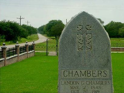 |
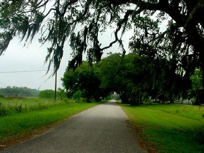
The Chambers
name is still prominent in the county.
The road near Wallisville
TE Photo, 2003 |
Historical
Marker - Hwy 61 and Magnolia St.
Events
at Anahuac Leading to the Texas Revolution
In the spring of 1832, Wm. B. Travis, Patrick C. Jack and other American
settlers in Texas were unjustly imprisoned by Col. Juan Bradburn,
commander of the Mexican garrison at Anahuac. Bradburn's refusal to
deliver his prisoners for civil trail caused alarm throughout the
American settlements, resulting in the organization of an armed force
of citizens for intervention to save their friends from trial by a
military court in Mexico. Rallying at Liberty, the Texans on June
10 went to Anahuac to parley with Bradburn, who agreed to free the
colonists in exchange for Mexican soldiers held by the Texans. When
Bradburn refused to keep his word, the Texans resolved to fight, and
sent to Brazoria for reinforcements
of men and cannon, thus precipitating the Battle of Velasco on June
26, 1832. These events were climaxed by the arrival of the Mexican
military commander from Nacogdoches,
who resolved the conflict by releasing the colonists and placing Bradburn
under arrest. Mexican resentment aroused over the events at Anahuac
and Velasco was a contributing factor
in the development of the Texas Revolution.
1965 |
Historical
Marker - Fort Anahuac Park
Fort Anahuac
Known as Perry's
Point until 1825, Anahuac was a port of entry for early Texas colonists.
In 1830 the Mexican government established a military post here
to collect customs duties and to enforce the law of April 6, 1830,
which curtailed further Anglo-American colonization.
Situated on
a high bluff at the mouth of the Trinity River, Fort Anahuac controlled
access to East Texas settlements. Two 18-pound guns topped the 7-foot
thick brick walls of the bastion. Four-foot thick walls protected
the adjacent barracks, and an underground tunnel led to a nearby
powder magazine. Col. Juan Davis Bradburn, commander of the Anahuac
garrison, angered Texas colonists by conscripting labor and supplies
to construct the fort and by failing to control his disorderly troops.
In 1832 he unjustly imprisoned William B. Travis, Patrick C. Jack,
and other settlers here. When he refused to release the men, armed
conflict erupted between Texas and Mexican forces. The confrontation
here, which also sparked fighting at Velasco
and adoption of the Turtle Bayou resolutions, resulted in Bradburn's
dismissal and the removal of Mexican troops from the post. Today
the ruins of Fort Anahuac are a physical reminder of events that
kindled the drive for Texas independence.
1976
|
Historical
Marker - Hwy 61 and Washington Ave.
Lone Star
Canal
Berriman Richard
Garland (1840-1918), a native of Indiana, saw the need for fresh water
for rice crops in east Chambers
County. Garland and A. L. Williams began in 1902 acquiring land
and constructing this irrigation canal. It started at the mouth of
Turtle Bay, now known as Lake Anahuac. In 1904, "Lone Star Canal Company"
was incorporated. E. O. Emerson and Burt H. Collins directed the business
in 1906. Sailing vessels anchored next to the warehouse carried the
rice to market. In dry seasons, salt water backed into Turtle Bay
and into the canal, killing the rice crops. To prevent the damage,
the Trinity River Irrigation District formed in 1911 and built a dam
and locks at the mouth of the bay. Thomas S. Ellis changed the name
to "Anahuac Canal Company" in 1914. After the 1915 hurricane destroyed
the dam, pumping plant, and warehouse, the company changed owners
several times, closing from 1927-32. In 1932 four men purchased the
canal, resumed the name "Lone Star Canal," and reopened operations.
In 1947 the Chambers-Liberty Counties Navigation District purchased
the canal. Water is available for industrial as well as agricultural
use with the goal of improving the economy of the area.
1979 |
 |
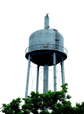
Anahuac's water
tower
TE Photo |
|
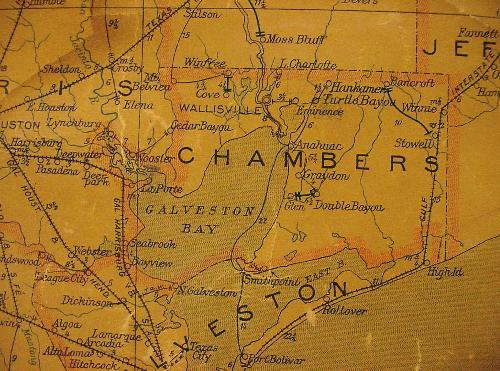
1907 Chambers
County Postal Map showing Anahuac
(Above "M" in "CHAMBERS")
Courtesy Texas General Land Office
|
| Texas
Escapes, in its purpose to preserve historic, endangered and vanishing
Texas, asks that anyone wishing to share their local history, stories,
landmarks and vintage/historic photos, please contact
us. |
|
|

 Texas
Gulf Coast
Texas
Gulf Coast East
Texas
East
Texas Central
Texas North
Central
Texas North Central
Texas South
Central
Texas South Texas
Panhandle
Texas
Panhandle South
Texas
South
Texas Texas
Hill Country
Texas
Hill Country West
Texas
West
Texas Texas
Ghost Towns
Texas
Ghost Towns Texas
Counties
Texas
Counties