|
Texas
| Trips
Tag
Along with Barclay
on Texas Photography Trip #94
(More appropriately - Who or what is Barclay?)
June 8 - 12, 2014
by Barclay
Gibson |
|
Texas
Escapes
thought it might be of interest to readers to become virtual passengers
with me on one of my
dedicated photography trips to Texas. My South Texas Loop Trip
taken June 8 - 12 was my 94th such trip. This trip will be as much
a challenge for me to put into words as it will be for you to come
along for the ride. Fortunately, having just returned from South
Texas, the details are still very fresh in my mind.
|
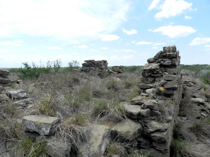
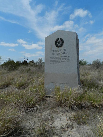
Poblacion
De Dolores TX Centennial Marker location
Photo courtesy Barclay
Gibson, June 2014 |
First,
a little background. All this Texas stuff started innocently enough
back in 2002 after reading James Michener's book Texas and buying
Kelsey and Dyal's book on Texas
courthouses. About this same time, I bought a map program, designed
for Windows 3.1, that was to become, and still is, my best resource
for old back-road churches, cemeteries, and schools. Seeing that there
were several nice courthouses within driving distance of Carlsbad,
New Mexico, I took my first �dedicated� Texas photography trip on
April 23, 2002. The road map I used was so old, HemisFair 1968, that
I didn't even know that an interstate highway ran through Ozona!
I went to places I had never heard of before, towns by the name of
Barnhart, Mertzon,
Eldorado,
and Bakersfield.
I even saw the grand
old courthouse at Sherwood.
By saying dedicated photography trip, I mean this was the 94th Texas
trip planned solely for the purpose of photographing historical sites
in Texas. The number doesn't include trips from Carlsbad to El
Paso, Lubbock,
Midland,
or even Dallas, for shopping
or to see relatives. Dedicated trips are intense, planned in detail
as much as possible to see as many Texas sights as possible in as
short a time as possible. If it is daylight, I should be driving to
a destination or taking pictures, or both. There is no time for sit-down
meals during daylight. Only if there is an emergency is there any
time to stop other than for gas or to change a blowout or flat tire
(which to date have not really been emergencies as much as bonus adventures).
At first, still using my 35mm film camera, I only took day trips from
Carlsbad, sometimes driving up to 20 hours. I once drove from Carlsbad
to see courthouses
in San Antonio, New
Braunfels, San
Marcos, Austin, Llano
and Mason,
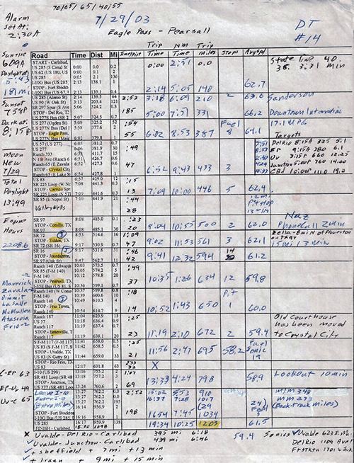
all in 16 hours. Looking back to Trip #14, I still don't know how
I was able to drive over 1,200 miles going first (get your map out)
down to Eagle
Pass, east to Tilden,
up to Jourdanton,
back west to Batesville
up to Junction,
and back home. I drove 1,203 miles, saw 13 current and former courthouses,
in 19 hours, 34 minutes all while driving at very near the speed limit
and taking more than seven rolls of film. |
 |
| Also pertinent
to this story is the fact that my wife and I moved from New Mexico
to Oregon in July, 2012. That means Southwest Airlines and New Mexico
Airlines have been added to my travel plans just to get me from Portland
to Carlsbad, still my base of Texas operations, in a timely manner.
In Carlsbad, I have been able to keep my trusty old 160,000+ mile,
four-wheel drive '99 GMC pickup in storage till it is time to dust
it off, gas it up and prepare for another trip into the vast interior
of Texas. This old truck was replaced with a very similar '07 four-wheel
drive GMC pickup, which is now with us in Oregon. The old pickup is
the same one that took me on the original Trip #1 back in 2002. |
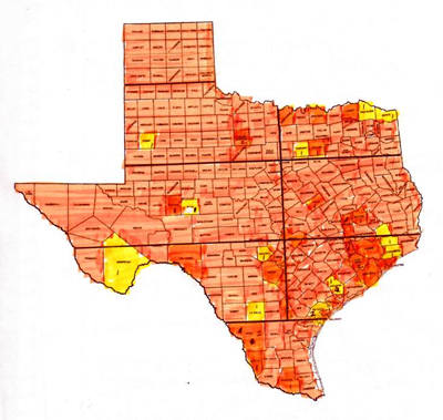
| "The orange
color shows counties where I've seen all the markers. Yellow ones
still have one marker to go except for Refugio County which has two.
[It] shows how scattered the remaining counties are." - BG |
The
planning for this last trip began in early April 2014. First off,
I arbitrarily decided to make the trip no more than five or six days
long. Maybe leave on a Sunday after church and return Thursday or
Friday afternoon. Originally I roughed out a route to see 14 of the
remaining 20 1936 Centennial
markers that I have not yet seen. The trip soon became too complicated,
ballooning to over 2,500 miles. Ten of the 14 markers were on private
property, each one would require multiple phone calls, call-back messages
and emails to obtain permission, set arrival times to match busy schedules,
or arrange for someone to take me to the marker. Striking off five,
I narrowed the number to a more attainable goal of nine markers. These
were located in La
Salle, Webb, Zapata,
Hidalgo, Jackson,
Irion, and Reagan
Counties, requiring only six private property appointments. The
route was now a more reasonable 2,200 miles, quite doable by leaving
Sunday afternoon and returning to Carlsbad Thursday evening.
One of the objectives I had in mind for this trip was to schedule
another visit with some of my fellow volunteer Centennial
marker hunters; Ruthie
Cade, Charlotte Phillips, and Sarah
Reveley, for a quick reunion lunch in San
Antonio. Ruthie
and Charlotte would be out of town June 6 - 14. I duly noted this
on my calendar. As things began to kind of fall together, I got a
call from a woman in Mertzon
I had asked to help me with contact information for two markers in
Irion County and one
in neighboring Reagan
County. We had it all set to see the three markers. There were
several other interested people who wanted to visit all three makers,
but the only week available for everyone was June 8 - 14.
Hurriedly, I made reservations for flights so that I could be in Irion
County on Thursday of that week. Only then did I realize that
was the one week Ruthie
and Charlotte were unavailable. Too late. Tickets had already been
bought. Another phone call I had to make was to apologize to Ruthie
for my blunder.
Now that the date for the trip was firmly set, it was time for me
to finalize the remaining marker visits. The three women who owned
the property in Jackson
County where a Centennial
grave marker was located, again refused to let me see it. Now I was
down to eight markers. A few days later, the woman in La
Salle County, who had canceled on me a couple of times before,
started putting me off again. Let me say at this point that things
like this never bother me as there is no end to interesting, historical,
back-roads things to see in Texas. I
have marked my maps so that in any area where I have a little extra
time all I have to do is look at my maps to find something new to
see. There is no such thing as having nothing new to see or photograph
in Texas.
The marker in Zapata
County, titled Poblacion
de Doleres, is right on the river in a deserted area where the
Border Patrol had issued a warning to not enter alone or unarmed.
I was getting pretty queasy about that one. I had a college professor
friend who assured me that Laredo
was much safer than news reports made it to be. He wanted to go with
me to the marker. That made me feel a lot better about it. |
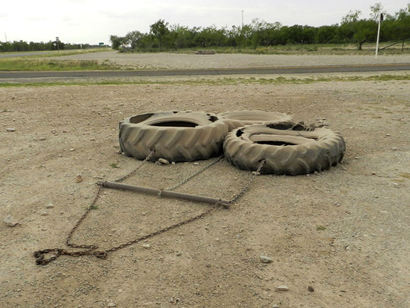 |
The
well worn border patrol drag tire
Photo courtesy Barclay
Gibson, June 2014 |
|
After arriving
in Carlsbad, final preparations had to be made. My pickup, Old Blue,
was in pretty good shape, considering. Years ago I quit worrying
about some of the warning lights that continually flashed on the
instrument panel. Her tires still had a lot of miles on them, but
her air conditioner needed a re-charge. Her driver seat padding
had long ago given out so that an extra cushion was always needed
while driving. Packing an extra spare tire, spare gas, an extra
tire jack, battery cables, a tow chain, and my trusty bed roll,
just in case I broke down out in the country somewhere, it was all
set to go. Don't tell anyone, but I also carry the truck title with
me just in case I have to abandon it in some small Texas town.
Here is how the trip was lining out. Sunrise this time of year was
about 6:30 am. Sunset was about 8:30 pm. That made for more than
14 hours of daylight for taking pictures. One thing I learned the
hard way: Don't be in oil field territory at night without a room
reservation. Twice I have used my sleeping bag because I didn't
plan ahead. My reservation for Sunday night was at a �seen better
days� motel in Uvalde,
Tuesday night would be in another of the same genre in Corpus
Christi, Wednesday night in one of my favorite out of the way
Texas motels, the Wharton
Tee Pee
Motel, and Thursday night in another, shall we say, �rustic�
motel in Mason.
In
making appointments like I do, there is a fine line between calling
too often, thus giving the land owner, the guide, or a contact person
another opportunity to back out, and not keeping them informed as
to changes in plan, arrival time, or maybe others who might want
to see the marker with me. A few days before leaving Oregon, I called
the lady in Mertzon
to confirm everything was still set to see the three markers on
Thursday, June 12. Two of them were set for sure. The third land
owner might need to be called to reaffirm our visit. We debated
on who should make the call. I got the nod. Very soon after he answered
the phone, I could tell I was in trouble. I had either spoken with
someone else earlier or he had simply forgotten my call from a month
ago. Either way, his schedule was such that the visit was off. Now
I was down to seven markers.
Leaving Carlsbad Sunday afternoon, I had plenty of time to go a
little out of my way to see a few ghost towns north of Del
Rio and still get to Uvalde
just before dark. Sure enough, the La Salle land owner quit answering
my calls or returning my messages. Now it was down to six markers.
That was just as well as Monday was turning out to be a long day.
The visit to the Zapata
County marker for Poblacion
de Dolores, would take several hours. After that, I wanted to
have time to follow US Highway 83 down the Rio Grande, all the way
over to Harlingen,
and then drive north back up to my room in Corpus
Christi Monday night.
|
 |
| Originally,
the Professor and Sarah
Reveley both wanted to visit the La
Salle County as well as the Zapata
County markers. After the La
Salle County visit fell apart, we could use the time to make last-minute
arrangements for the Poblacion visit. That was when it was decided
Sarah would drive 140 miles from San
Antonio as I drove 120 miles from Uvalde,
meeting Monday morning at the I-35 Texas Travel Center north of Laredo
at 9 am. From there we would convoy on to Laredo,
where we would meet the Professor at his house. |
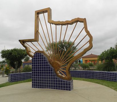
Texas silhouette
at The Texas Travel Center north of Laredo
Photo courtesy Barclay
Gibson, June 2014 |
|
He would first
accompany us to two Centennials in downtown Laredo.
From there we planned to pick up the key to the property to see
the Poblacion marker located just south of the Zapata
County line. Originally, the land owner said he would only provide
us with access and directions to the marker. Because the marker
is located right on the Rio Grande, it is a very convenient place
for smugglers to bring in drugs. Thankfully, almost at the last
minute, the land owner decided to go with us. Let me add here that
he related to me that the property with the marker is a part of
the famous Jose Vasquez Borrego Spanish Land Grant from the mid-1750's
of which his wife is a ninth generation heir.
When Sarah and I first met the Professor outside his home in Laredo,
he mentioned that his eyes were a little sore and were getting sensitive
to the light. He had been working with some house plants the night
before and must have gotten some of the fluid from one of the plants
in his eyes. Not thinking more about it, he drove us to both of
the Laredo
markers. After seeing the markers, we met up with the land owner.
It was time to head south to the Polablion
de Dolores marker. As my plans were to continue on south after
seeing that marker, we decided to take three vehicles; I drove alone,
the land owner had his SUV while Sarah rode with the Professor in
his Jeep.
As
it had been many years since anyone had visited the marker, the
padlocks weren't very cooperative about opening up. Finally, after
passing through the last gate and only taking one wrong turn when
the trail all but disappeared, we were nearing the river. Earlier
I mentioned flashing instrument panel lights. One of the lights
that sometimes flash is the one that says, �Check 4 Wheel Drive.�
I sure didn't want that one to come on now as the ruts were getting
somewhat challenging. Also, the mesquite was getting pretty thick
so I persuaded the land owner to ride in my old truck as a few more
scratches on Old Blue wouldn't hurt anything. Then in front of us,
just above the rise was the now familiar shape of a gray granite
slab. I can't explain the feeling, but every time I see a new marker,
it's like making a new friend.
|
 |
|
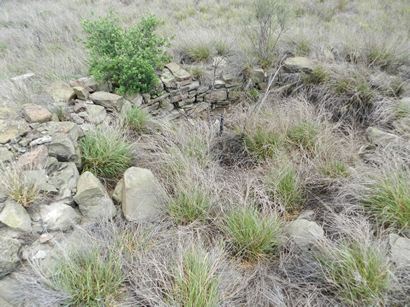
Of all the
planning I had done to see this marker, I had its location off by
more than two miles. Even the Texas Historical Commission lists
the marker in adjacent Webb County, not Zapata County. This is another
example of how little is known about these monuments that were placed
all over the state nearly 80 years ago.
Thankfully, the terrain surrounding the marker was pretty open so
we felt fairly safe. While staying alert, we were able see the marker
itself as well as survey and photograph the rock ruins of the old
Dolores mission and its torreon, or circular enclosure used for
protection against attack. The inscription on the marker commemorated
the founding of Poblacion
de Dolores in 1750. It was the first Spanish settlement north
of the Rio Grande.
|
 |
|
Not
wanting to spend any more time there than necessary, we were ready
to depart. As I was concentrating on the marker and its surroundings,
I didn't realize the Professor was having so much trouble with his
eyes. He could hardly open them due to the extreme pain and their
sensitivity to the bright sunlight. Being unable to do anything
but shield his eyes, he was in no shape to drive back to Laredo.
Even in his pain, he thoroughly quizzed Sarah about her ability
to drive his Jeep in this kind of terrain. She assured him that
she had grown up on a cattle ranch and was used to pulling trailers,
as long as she didn't have to back one.
We were soon on our way back to civilization. I drove the land owner
back to his vehicle and we all exited the property. Believe me,
it was such a real relief to be back on a paved highway. Sarah safely
delivered our professor friend back to Laredo
where he could seek immediate medical attention, and I was on my
way to the next marker. The next day I called to see how he was
doing. Having not quite fully recovered, he told me what caused
all his misery. Here is a warning for anyone reading: the house
plant he was working with is commonly called pencil cactus.
After doing a little checking on the pencil cactus, I found that
the plant secretes a sap that acts similar to lye if it gets into
your eye. In severe cases, this can cause blindness. A potted pencil
cactus makes a nice house plant and seems to be popular as they
are common in nurseries. The Professor joked that he had hiked to
this site 45 years ago and didn't notice the marker. This time he
couldn't open his eyes enough to see the it. He has now been there
twice and still hasn't seen the 1936
Polablion de Dolores Centennial marker.
Back on the highway, it was a little after noon on Monday. My trip
was really just beginning. Stay tuned for the next
episode of what was over the next hill.
© Barclay
Gibson
August 1, 2014 Column
See The
Conclusion to �Tag Along with Barclay on Texas Photography Trip
#94" by Barclay Gibson ›
|
 |
|
|