|
|
As
the reader might remember, a group of us, including the land owner,
a Laredo college professor, fellow marker hunter, Sarah Reveley
from San Antonio, and myself, had just visited the Poblacion
de Dolores Centennial marker that was located south of Laredo
right on the banks of the Rio Grande. Because of the remoteness
of the area, we had some concerns about our safety as drug smugglers
were known to cross the area. On top of that, our Professor friend
was unable to see because he had accidentally touched his eyes the
night before after handling a poisonous pencil cactus so that his
eyes were extremely sensitive to bright light. It was now time for
us to beat a hasty retreat back to the highway.
As the last gate was closed and locked, we all said our good byes,
and I told the land owner how much I appreciated him accompanying
us to the marker site. Sarah
felt comfortable as fill-in Jeep chauffeur for the Professor. At
that point he was in so much pain, he couldn't even tell where he
was. I headed south while everyone else was on their way back to
Laredo.
As I began to make plans for the rest of the day, other things were
going through my mind. It's a weird feeling. The whole time I had
been planning to see the Poblacion
marker, it was with the feeling of, �Do I really need to see
this thing?� or �Is it worth whatever fears I might have about being
in that area knowing things might not turn out well?� My mind was
trying to replace any imaginations I might have had for the last
several weeks with the reality of how it turned out. The main thing
was that everyone was safe. Most of us were able to enjoy seeing
it.
My route following US 83 to Harlingen
and then US 77 up to my room in Corpus
Christi was simple enough. With a few side trips it was about
330 miles. Thanks to Google, I knew driving time was about five
and a half hours thus giving me about two and a half hours to see
the various sights between here and there and still arrive in Corpus
Christi around sunset. The main thing I wanted to see was the
Iwo Jima Memorial Statue near the Marine Military Academy in Harlingen.
Now I could settle back and get into the routine of the trip, stopping
at a couple of small towns to photograph churches and an old bridge
on display in a park. The last time I was marker hunting in this
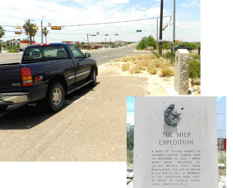
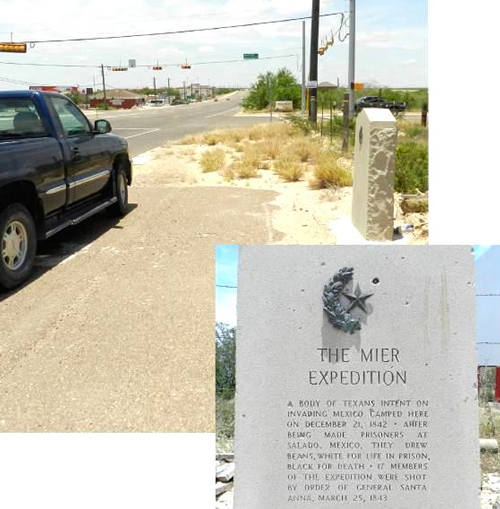
area back in 2011, I was able to photograph the Starr County Centennial
marker for The Mier Expedition which had been placed in storage
for safe keeping at the local TxDot yard while some road work was
being done north of Roma.
Recently it had been re-set back in its original location right
on US 83, near the Roma High School. Since I had this one, it wasn't
one of the six for this trip. Sadly, when these markers are placed
for easy access to the public, vandals also take advantage of their
availability. In this case, half of the bronze wreath had been crudely
pried off and evidence of hammer blows to the granite were visible
across the face of the marker.
|
 |
Somewhere around
Roma, I was starting
to get a little hungry. The effects of the early morning HEB donuts
and motel coffee were long gone. In planning my route, I found an
all-you-can-eat chicken fried steak restaurant in Corpus
Christi near my motel. That sounded like just my kind of place;
not much of atmosphere but lots of good food. The problem was their
website said it closed in mid-afternoon, and I knew there was no way
to be there that early. Just to make sure, I even made two separate
phone calls to confirm their closing time. Having no other options,
I fell back to my usual lunch of salt and sugar. Some Fritos with
a can of bean dip washed down with a Cherry Coke, that is. Kind of
makes your mouth water, no?
Next I went down to Los
Ebanos to see the
last hand-drawn ferry across the Rio Grande. Not knowing the schedule,
I missed seeing it because nothing was going on. Then a quick run
north of Mission
to see the Hidalgo County Centennial marker for William Jennings Bryan.
I don't know what he had to do with the Texas Revolution but he has
his own marker near his home site, appropriately placed at the corner
of 2 Mile Road and Bryan Road. This one, too, was in storage last
time I visited, but I had not been able to see it. The TxDot man told
me there had been a car wreck at that intersection and the marker
was knocked over. It was scheduled to be put back in place the day
after I was there. This was marker number four.
Since I was right next to McAllen,
it was easy enough make a quick run downtown to get some pictures
of the Cine El Rey movie theater. There are quite a few sites on my
list in downtown Harlingen,
but by now it was nearly five o'clock, and I still had a long way
to go before nightfall. I decided to scratch my plans for downtown
Harlingen with
its churches, murals, theaters, and depot and just make a couple of
quick passes by a restored Sinclair gas station and then go directly
to the Iwo Jima Memorial. I understand this statue is the original
sculpture from which the bronze Arlington Cemetery statue was made.
Anyone who has seen either can't help but be moved by the size and
detail on display. |
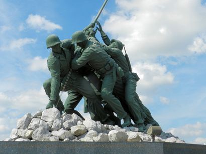 |
The
Iwo Jima Memorial Statue
near the Marine Military Academy in Harlingen
Photo courtesy Barclay
Gibson, June 2014 |
It
was time to set my sights north to Corpus
Christi. One of the challenges any sightseer has, whether in Paris
or Rome or South Texas,
is deciding what you really want to see and what can be bypassed.
Cut too little and run out of time to see some priority sight later
on. Cut too much and you have extra time on your hands. With only
a little over two hours to Corpus
Christi and more than three hours of daylight left, I wondered
if I should go back to downtown Harlingen
and see those things I missed or press on. By this time I'd been on
the road for over eleven hours. I was still hoping for some last minute
breakthrough in my efforts to see the Jackson County marker. My plan
was to have two chances to see it; one in mid-morning. The other in
late afternoon. I decided to go ahead and check into my room then
cross the Nueces Bay Causeway to see some of the sights planned for
Tuesday, thus shortening that day to better ensure keeping my options
open should the Jackson County marker become available to see.
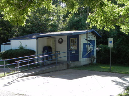
I only made three significant stops on my way north. Once for pictures
of the small, now closed, Armstrong
Post Office, somewhere between Raymondville
and Riviera.
Then to see the Navy A4D Skyhawk jet displayed on a pedestal stand
beside the highway near Kingsville.
The last stop was in Nuecestown,
just west of Corpus
Christi, to see the old school, cemetery, and associated aluminum
historical markers. After having enjoyed such a filling lunch earlier,
I still wasn't hungry enough to look for a place for dinner. So, after
checking into my room, I was back on the road to Gregory
to see its depot, City Hall, and downtown. On the west approach to
the causeway I took another photo of the aircraft carrier USS Lexington
framed by the passenger side window. I don't know how many pictures
of the ship I've taken this way. |
 |
After
seeing the sights of Gregory,
I was on my way back to my room on I-37 in West Corpus Christi right
at sunset. Now for more trip minutiae. Wanting to miss the early morning
traffic, I decided to leave early enough to be across the causeway,
eat breakfast at an IHOP in Portland,
and be in Refugio
soon after daylight.
Edna, in Jackson
County, is only about an hour from Refugio.
With still no word about permission to see that marker, I proceeded
with my route for the day, which was to work my way north seeing small
towns, country churches, and cemeteries up to Fayette
County, north of I-10, then back southeast to Wharton.
On the way up US 183 was an interesting old Hochheim
Post Office that I particularly wanted to see. Wouldn't you know that
right at Hochheim
there was road construction with one-way traffic right through that
area. If I pulled out of line to see the post office, I would have
to wait for my turn again with the next line of northbound traffic.
As traffic was kind of heavy that morning, it might have been a long
wait.
Continuing to work my way north through the small towns and/or ghost
towns of Weser, Hopkinsville,
Clinton, and Saturn,
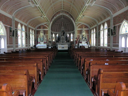
I finally peaked out at Cozy
Corner, a little southeast of La
Grange. That was when I realized I was only a few miles from one
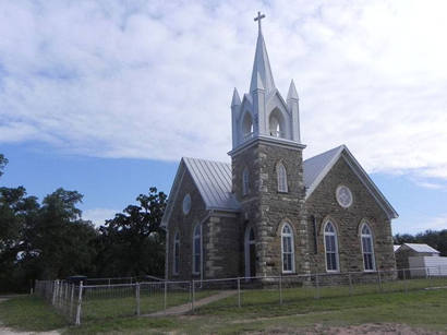
of the Painted
Churches at Ammannsville's,
the St.
John the Baptist Catholic Church. One should never pass up a chance
to visit, even re-visit, one of these beautiful churches. Quite often
the sanctuaries are available for public viewing, as this one was.
|
 |
|
It
was at Ammannsville
that I first realized I had been on the road for seven hours since
breakfast. I was already looking forward to an enchilada/taco/relleno
dinner along with two kinds of salsa with chips at the Wharton Los
Cucos. Having learned from previous encounters there, I needed to
be sure to enter the premises on a completely empty stomach. One
left-over donut from the Uvalde HEB along with some orange juice
from my ice chest would just about do it.
My route would now take me roughly southeast through Swiss
Alp, Oakland,
Morales, Edna
(for my second window of opportunity for the Jackson County marker),
Markham,
Danciger,
Pledger, Burr and back up to the Wharton
Tee Pee Motel. After my delightfully delicious Mexican dinner at
Los Cucos, which fulfilled every imagination, I was fully ready
for a quiet, restful night in my teepee.
|
 |
So
far, on this trip, I had taken nearly 1,000 photographs, mostly while
still in the comfort of my extra-cushioned, collapsed driver's seat.
The goal for the next day was to work my way back up to I-10 seeing
the usual country churches, old and/or former post offices, cemeteries,
and a few aluminum historical markers in Altair,
Rock Island,
Sheridan,
and New Bielau.
Then more of the same in an area south of Seguin.
I had one thing to photograph in San
Antonio, and then to Gruene,
and northwest, mostly on back roads to my reservation in Mason.
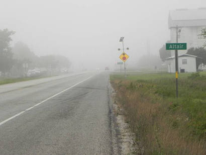
As expected, the next morning there was no way I could even entertain
having breakfast. A mug of hot Bucc-ee's coffee would do nicely. I
was back on the road before daylight in order to be in Altair
by sunrise. I should have expected the greeting of the East Texas
fog. Lots of places experience fog, nothing unusual about that. But
an East Texas fog somehow seems to be different, denser in some way.
Being from New Mexico, I'm really not a good judge of such things,
and being on a photography trip with specific sights in mind, this
fog was not a welcomed sight. |
 |
|
With
such detailed routes as mine are and with the ever present time
crunch, I never have the luxury of waiting for just the right sunlight,
the perfect cloud formation, or for the fog to clear. I have to
take photographic opportunities as they present themselves. They
did. Before I knew it, the fog lifted and it was business as usual.
Driving south of Seguin,
I was able to see the Sweet
Home Church as well as the closed school across the road, the
Elm Creek Church and cemetery. After a brief tour of New
Berlin, it was north to picturesque Marion
and Cibolo.
I had asked Sarah if she would drive me to the downtown post office
across from the Alamo
as parking was usually unavailable. She let me out, and I went in
to photograph the fourteen WPA era murals. After taking those pictures,
I violated Trip Rules, as we had a sit-down lunch at the Pig Stand.
Then it was on to Gruene.
If you don't know how Gruene's water tower got the dent in its cap,
you'll just have to read the
fascinating story on TexasEscapes.
I had planned on seeing a few things in San
Marcos, but needing to make up some time, I took a shortcut
through Fischer,
Blanco,
and Albert.
About this time I thought I would try one more time to get permission
to see the Irion County marker that didn't work out earlier. It
was worth a try, but the phone call went the same way as before.
After only a couple of stops in Fredericksburg,
it was on to Hilda
and Art
before arriving in Mason
for the night.
|
 |
|
The room wasn't
quite what I had in mind. I have had rooms with only cold water.
This one had only scalding hot water in the sink, including the
shower. Believe me, it was a quick shower. Thankfully the ice bucket
was handy for a little extra water to make the toilet flush. To
get my mind off the situation, there was time to get to the Willow
Creek Cafe before closing. Their tasty Philly cheese steak sandwich
helped me feel better since it was my only meal of the day. Even
then I saved half of it for lunch tomorrow.
Back at the motel, the noisy air conditioner was barely keeping
the room cool. It ran all night so I was only too happy to hear
my alarm clock go off at 5:30. A mug of Stripes' station coffee
and I was off again. That's when I realized I had forgotten to charge
my phone during this whole trip. I normally don't use it much at
all so the battery will easily last a week or more. It has seen
a lot of use in the last few days so now the screen was blank. I
always call home every morning, but now I couldn't check in. I knew
my wife would be concerned.
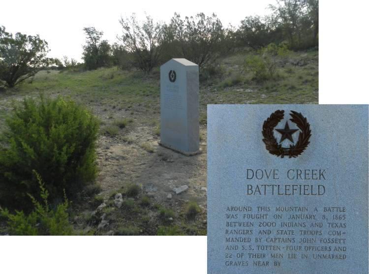
Appointments had been made to visit two Centennial markers, the
Irion County Dove Creek Battlefield marker and the Reagan
County Grierson Spring marker. Several people were interested
in seeing the markers. We agreed to meet in Mertzon
at 8 o'clock at the Irion County Museum which is right across the
street from the county
courthouse. Because I was a little early, I imposed on the deputies
at the sheriff's office to see if I could charge my phone until
we were ready to leave. They were very gracious and let me plug
in my phone. As people in our group began to arrive, I got acquainted
with each one. We had the lady who set up the appointments, her
husband and their son, the Mertzon City Manager, who would escort
us to the Dove Creek Battlefield marker site, a lady from San
Angelo who had an interest in Irion County history, and a couple
from Reagan County,
who would take us to the Grierson Spring marker. When everyone was
ready to leave, I picked up my phone. Even with such a short charging
time, it had enough juice to last till I got home.
I immediately called my wife, sure she had called the motel in Mason
and was told I had checked out. I happened to mention that I was
planning to eat my sandwich later, but the motel room didn't have
a refrigerator and the ice machine wasn't working. She was concerned
that it wasn't safe to eat. To be on the safe side, I took a deep
breath and disposed of it.
We convoyed out of town in three vehicles with the city manager
in the lead. The marker was well off the road and behind several
locked gates. Again, even with all my prior research of information
about its location, we would never have found it without our guide.
We spent about twenty minutes on location talking about the history
of the county and of the Dove Creek Battle itself. According to
the text on the marker, the battle took place toward the end of
the Civil War in January, 1865, when Texas Rangers and State Troops
battled mostly Kickapoo Indians. The dead were buried somewhere
nearby. On the way back to the highway, we were taken to the head
waters of Dove Creek which formed a very nice swimming hole. It
was quite a sight to see. That was the fifth Centennial.
|
 |
Dove Creek Battlefield Marker
Click on photo for large image
Photo courtesy Barclay
Gibson, June 2014 |
|
We
lost two of our group as the city manager needed to get back to
his duties and the woman from San
Angelo had some obligations. The remaining six left to see the
Reagan County Grierson Spring Centennial marker which was an hour
and a half away. The marker is located southwest of Big
Lake in a wide, open, barren territory. Again, there were a
lot of rough, dusty, and rocky roads to travel, and gates to unlock.
The marker was placed on the side of a canyon near the trail we
used to approach it.
First, we hiked down the canyon to see the actual spring. We then
hiked north along what is left of the old stage route. It is amazing
how evidence is still so clearly visible of the path worn by the
mules, horses, freight wagons, and stage coaches so many years ago.
Down in the canyon bottom we could see the remains of several structures
where the rock walls are still standing. There appeared to be what
might have been the kitchen, a blacksmith shop, officers quarters,
and a corral. Even from a distance it was obvious that it was quite
an undertaking.
The wording on the marker itself states that the Grierson Spring
is named in honor of General Benjamin Grierson, who commanded federal
troops in the area. An outpost was established there in 1878 as
a way station between Fort
Concho and Fort Stockton.
It was abandoned in 1882. This marker, too, had been vandalized
even as remote as it is. The owners, at their own expense, found
a replacement bronze star and wreath to restore the marker to its
original condition. This was the sixth and final marker I had planned
to see.
|
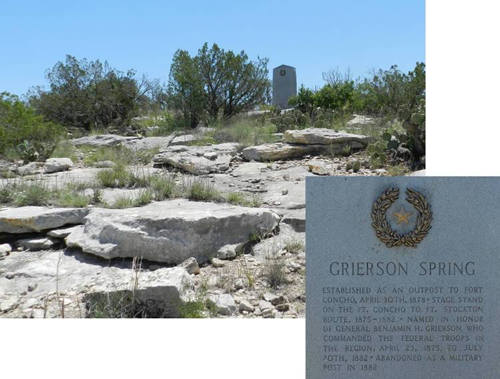 |
The
Grierson
Spring Centennial marker
Click on photo for large image
Photo courtesy Barclay
Gibson, June 2014 |
|
After
all this, the Reagan
County couple graciously treated us to a totally unexpected
tailgate party miles from anywhere and anybody. We enjoyed sandwiches,
chips, drinks, and cookies. It was a perfect ending for a perfect
day. And, for me, a perfect trip. It was now only about two o'clock
in the afternoon. Most of the objectives of the trip had been accomplished.
I had met many new people and had a wonderful, very memorable time.
The thermometer was hovering a little above 100 degrees. Again Old
Blue had performed beautifully. I had driven over 2,000 miles and
taken more than 1,600 pictures. It was time to head home.
|
|
|