|
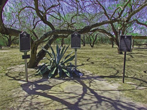
Historical markers
in Relampago
Photo courtesy Ken
Rudine, March 2008 |
History on
an Onionskin
Rel�mpago
is the Spanish word for "lightning flash." The land had originally
been part of a 1790 land grant that remained undivided until 1848.
When Juan Jos� Ball�, the original grantee died, this portion of the
grant fell to his son, Vicente Hinojosa. Vicente�s son, Cirildo is
credited to be the first settler on the portion of land that was to
become Relampago.
In 1852 Thaddeus Rhodes of Brownsville
purchased a large plot and two years later a rancher named Jos� Mar�a
Mora bought the neighboring plot (1,400 acres). Rhodes and Mora merged
their holdings into the Relampago Ranch. By 1880 the community had
158 residents.
In the mid 1880s the community was serviced by the Brownsville
stage line. In 1902 a parcel of land was sold to the American Rio
Grande Land and Irrigation Company and six years later the town was
platted by a subsidiary of ARGL&I. The town was all but washed away
by a 1909 flood, which accounts for the notable lack of buildings
today. A post office was briefly open from 1910 to 1908.
The old store (established by Mora in the 1880s) closed in the late
1920s. 200 people continued to live here into the 1960s but the development
of a colonia rivaled the town, eventually taking the identity of the
town by right of population. In the mid 1980s the population was down
to 135.
The Relampago Cemetery has been used for several generations of the
Mora and Rhodes families and the land is now used primarily for the
growing of onions, particularly the 1015 variety. |
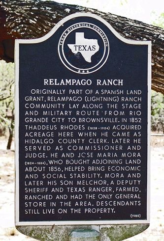 |
Relampago Ranch
historical marker
Photo courtesy Ken
Rudine, March 2008 |
Historical Marker:
from Mercedes, take FM 491 S about
3 miles, then go W on US 281 about 1.2 miles
Relampago Ranch
Originally part
of a Spanish land grant, Relampago (lightning) Ranch community lay
along the stage and military route from Rio
Grande City to Brownsville.
In 1852 Thaddeus Rhodes (1828-1904) acquired acreage here when he
came as Hidalgo county clerk. Later he served as commissioner and
judge. He and Jose Maria Mora (1824-1884), who bought adjoining land
about 1856, helped bring economic and social stability. Mora and later
his son Melchor, a deputy sheriff and Texas Ranger, farmed, ranched
and had the only general store in the area. Descendants still live
on the property.
(1980) |
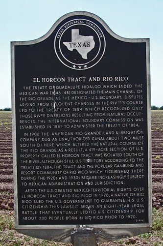
El Horcon Tract
and Rio Rico historical marker
Photo courtesy Ken
Rudine, March 2008 |
Historical Marker:
US 281, 0.5 Miles E of intersection of US 281 and FM 491 (S. side
of Rd), Mercedes
El Horcon Tract
and Rio Rico
The Treaty of Guadalupe
Hidalgo which ended the Mexican War (1846-48) designated the main
channel of the Rio Grande as the Mexico-U.S. boundary. Disputes arising
from frequent changes in the river's course led to the Treaty of 1884
which recognized only those river diversions resulting from natural
occurrences. The International Boundary Commission was established
in 1889 to administer the Treaty of 1884. In 1906 the American Rio
Grande Land and Irrigation Company dug an unauthorized canal about
two miles south of here which altered the natural course of the Rio
Grande. As a result, a 419-acre section of U.S. property called El
Horcon tract was isolated south of the river. Although still U.S.
territory according to the Treaty of 1884, the tract and the popular
gambling and resort community of Rio Rico which flourished there during
the 1920s and 1930s became increasingly subject to Mexican administration
and jurisdiction. After the U.S. granted Mexico territorial rights
over El Horcon tract and Rio Rico in 1970, a native of Rio Rico sued
the U.S. government to guarantee his U.S. citizenship. This lawsuit
began an eight-year legal battle that eventually led to U.S. citizenship
for about 200 people born in Rio Rico prior to 1970.
(1994) |
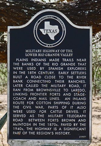 |
Military
Highway of the Lower Rio Grande Valley Historical Marker
Photo courtesy Ken
Rudine, March 2008 |
Historical Marker:
roadside park on US 281, 4 mile S of Mercedes
Military Highway
of the Lower Rio Grande Valley
Plains Indians
made trails near the banks of the Rio Grande that were used by Spanish
explorers in the 18th century. Early settlers built a road close to
the river bank connecting their ranches. Later called the Military
Road, it ran from Brownsville
to Laredo, linking frontier
forts and stagecoach and mail lines. An inland route for cotton
shipping during the Civil War, parts of it also were used for cattle
drives. It served as the military telegraph road between Forts Brown
and McIntosh in the 1870s. Paved by the 1940s, the highway is a significant
part of the region's history.
(1997) |
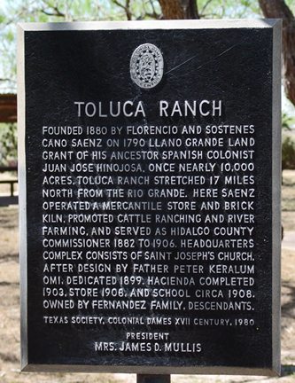
Toluca
Ranch marker
Photo courtesy Ken
Rudine, March 2008 |
| Texas
Escapes, in its purpose to preserve historic, endangered and vanishing
Texas, asks that anyone wishing to share their local history, stories,
landmarks and recent or vintage photos, please contact
us. |
|
|