|
|
On
Tuesday, July 19, 2016, I flew out of Portland International Airport
for what was to be my longest trip yet, both in time gone from Oregon
and for time on the road on a Texas Photography trip. And, as it
turned out, it was to be my most exciting and unusual trip, too.
Without a lot of boring details (but still with a lot of boring
details), we have Carlsbad friends who recently bought a retirement
home near Lake Athens, southeast of Dallas,
about 550 miles east of Carlsbad. As first-time home owners, we
wanted to be as much help for them possible. Therese asked if I
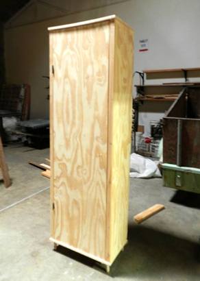
could build a broom closet for their guest bathroom.
Having only one photo of that corner of the bathroom area from which
to guesstimate heights, sizes and clearances, my wife and I designed
a simple, inexpensive closet that was decorative while giving the
maximum amount of storage space and could be cut from a single sheet
of plywood. I cut it out in Carlsbad and trial assembled it. Brad
would paint it once it was re-assembled in their house.
My trip was timed so I would be in Athens
the day after their move. Completely as an afterthought, since my
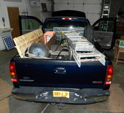
pickup would be empty, on Sunday, it was decided that I would carry
a load of things that would have been awkward and space robbing
in their small rental moving truck. Things like their foldable dog
kennel, their wheel barrow, a cast iron barbecue, ladders, yard
tools, and, of course, their disassembled broom closet.
|
 |
| My load was well
secured and tied down, but from the picture you can see why I avoided
the interstates as much as possible. I spent Monday installing the
broom closet and doing odd jobs around the house. Things like cutting
and installing shelving in their master closet, tracking down a small
electrical problem, stabilizing a shower valve and picking up a four-drawer
file cabinet from Office Depot. |
 |
Now
that the first part of my trip was accomplished, my Texas Photography
Trip #98 could begin. But, backing up a bit, the basic itinerary of
the photography part of this trip had been in the planning for nearly
18 months starting in February or March of 2015. Of the something
over 1,100 Centennial
items placed all over the state of Texas in 1936, I only had about
a dozen historical markers and plaques not yet seen and photographed.
My original hope was to see six of these on this one trip.
All these markers were scattered from Northeast
Texas down to Gulf
coast and back west to a remote spot near San
Angelo in West Texas. All were deep inside private property requiring
multiple phone calls, messages and return calls to obtain permission
and set up appointments for my visit. Through my
travels in Texas, I had been trying to see these particular markers
on various occasions for upwards of five years.
As an added bonus, while researching for other markers, I heard of
another historical marker in Liberty
County that was way off the road near the Trinity River. It was
for the homesite of a prominent player in the founding of Liberty
County Texas. Everything about this marker made me think it just
might be an un-inventoried 1936 Centennial marker. In all of my Centennial
marker hunting, I have had the privilege of making only one such find.
That was when I discovered a pair of huge 1936 bronze Centennial plaques
dedicated to Davy Crockett that had been stored for up to 30 years
behind a drafting table in the Crockett City Hall. No one knew what
they were then and probably still don't know, even today.
I spoke with the Liberty
County property owner, and he very much wanted to take me to see
his marker, and I was very much looking forward to seeing it. My trip
was originally set for July, 2015, because the long summer days, nearly
14 hours, provided plenty of time for driving between distant markers
and time for good for daylight photography. But due to the complexity
of appointments, weather and other factors, I decided to put the trip
on hold and cancel all my appointments, room reservations and change
my airline reservations.
Now back to Athens,
July, 2016. By this time my goal for markers to be seen was down from
six to four plus the extra marker in Liberty
County. One of the original six, placed at a Chambers
County homesite for Sam
Houston, was well documented, good pictures were available and
its location exactly known. There was no compelling reason for me
to see it other than to mark it off my list. This could not be said
for any of the other five markers. None had good photographs. Locations
for some were only vaguely known. Of these five, one is a grave marker
in Jackson County,
southwest of Houston, that
I could never get permission to see. Over the years I spoke with the
owners multiple times. I even promised to take a rake, hoe and trash
bag to clean up the neglected cemetery. The answer had always been,
"No." It was "No" in 2015 and was still "No" in 2016.
My first appointment from Athens
on Tuesday was with the Red River County Historical Chairman who drove
me to the remote Centennial marker for Robert Hamilton, northeast
of Clarksville. Hamilton was a signer of the Texas Declaration of
Independence. My next appointment was at the Red River Army Depot
just west of Texarkana
to see the Centennial marker for Hardin Runnels, an early Texas governor.
At the Visitor's Center, I was photographed, background checked, and
escorted to the Hardin Runnels marker and Runnels cemetery both located
deep in the midst of long rows of WWII
ammo bunkers surrounded by hundreds and hundreds of Iraq/Afghanistan-era
Humvees, IED-proof armored personnel carriers and transport vehicles.
This marker was placed in 1936 before the property was taken over
by the government in preparation for WWII,
but it is evident that the Army has respected the marker and cemetery
for all these years. No photography was allowed except of the marker
and cemetery itself. |
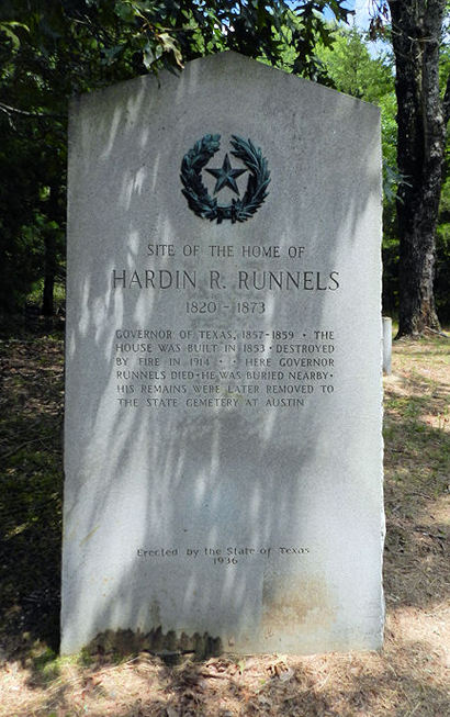 |
Site of Home
of Harkin R. Runnels Texas Centennial marker
Barclay
Gibson July 2016 photo |
From the Red
River Army Depot, I drove down to Shreveport, Louisiana, to see my
friend, Gerald Massey,
a fellow photographer for Texas Escapes
who I first met in April, 2010. I had been to Gerald's house once,
and he has been to Carlsbad at least twice. Gerald wasn't feeling
well when I arrived so we spent most of Wednesday at his house. I
dropped him off at the local YMCA so he could enjoy their hot tub
while I went on the local airport to see what was going on there.
(not much)
Thursday morning I left early enough to eat once again at the Petro
Iron Skillet Truck Stop, mentioned in my
Pulaski marker story, before sunrise. I was looking forward to
my 2:00 o'clock appointment to see the Liberty County marker near
the Trinity River. I had spoken with the Liberty
County property owner, and he seemed eager to take me to see his
marker. He even had his grandson call me and ask if I wanted to walk
the 1-1/2 miles to the marker, ride horses or take ATV's. I agreed
with the 83 year old owner that, "We don't bounce as high as we used
to, and hitting the ground hurts a lot more now."
I was very much impressed with the grandson each time I spoke with
him. He said he had arranged to have a crew mow around the marker
and had the ATV's all ready for my arrival even though he had several
very nice horses we could ride if we so decided. It soon became obvious
that my visit to this marker whether or not it proved to be a 1936
Centennial, might well be he highlight of my entire efforts to see
all the Centennials around the state. No one had ever gone to this
much trouble before to help me see a marker.
But first I had to get to Liberty.
In Nacogdoches
I re-photographed a lot of Centennial
plaques placed around the town. I was up a bit too early for good
lighting the first time through six years ago, thus confirming the
old adage, "No time to do it right the first time, but always time
to do it over." About 20 minutes out of Nacogdoches,
on my way to Groveton,
I saw four large buzzards up ahead busily working over some recent
road kill on the highway. Three of the huge buzzards escaped to the
left, but one decided to go right. Dodging too late, it hit with a
loud thud right of center of my grille. A quick search for common
buzzards says they weigh about three pounds. From the sound and feel
of that hit, I think this guy's feathers weighed that much.
I saw it fall to the roadway. Knowing the debris should be cleaned
from the bumper and grille, I began to slow. That was when I noticed
my truck beginning to smoke. My first thought was that some buzzard
parts had found their way to my hot exhaust manifolds. I came to a
stop just off the road. Expecting a bloody mess up front, I thought
it odd that all I saw was only faintly red. I used some of my emergency
water to wash it off and again thought it odd that it was so oily.
My thought was, "That buzzard sure was full of fat." Back it the truck,
I put it in gear to resume my trip. The truck wouldn't move. Into
reverse, again it wouldn't move. Only then did I realize that faint
red on the bumper wasn't buzzard fat, but it was transmission fluid.
That was what was smoking.
On went the hazard warning lights, and up went the hood. Of course,
with all the covers and shields there was nothing to be seen. I knew
right then there was no way I was going to make my 2:00 o'clock appointment.
My first priority was to find help either with a mechanic or with
a tow truck. My GPS listed a garage nearby. Wouldn't you know that
it was not a working number. That is when my phone went completely
dead. During my whole time with Gerald, I had forgotten to charge
my cell phone!
The GPS told me it was about 22 miles back to Nacogdoches
and nearly twelve miles east to Lufkin.
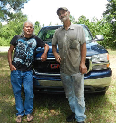
With no other options, I approached the dilapidated mobile home whose
driveway I was blocking. I knocked on the door and stepped back not
knowing what to expect. After a short time, a long haired, bare chested
man only a little younger than me, came to the door. I had barely
gotten the words, "I broke down. My cell phone is dead, and . . ."
out of my mouth, when he said, "Let me put a shirt on. I have a buddy
down the road who is a good mechanic. I'll take you there, and he
can fix you up." We introduced ourselves. I think he said his name
was Marvin. It may have been soon after that when I asked to use his
phone to call about my 2:00 o'clock appointment. The grandson was
disappointed that I couldn't make it and would tell his granddad.
Marvin's friend lived about a mile away. I sat in the truck while
he went to his friend's house. I think his name was David. Soon David
came out smoking his cigarette and drinking a cup of coffee. Marvin
drove me back to my truck, and David followed in his. Working only
with a screwdriver David soon had the radiator cover off and the grille
removed. The problem was immediately obvious. The bird had broken
a part of my grille which, in turn, had punctured a small tube in
the auxiliary transmission radiator.
Since this radiator was only needed with heavy hauling and towing
or in mountainous country, the simplest solution was to bypass the
damaged radiator completely. All that was needed was about two feet
of transmission tubing, some clamps and about six quarts of transmission
fluid. Just before David and I left for Lufkin
to get these items, I asked Marvin if he would plug my phone in to
have it charging while I was gone. It took David and me a good forty-five
minutes to the auto parts store and back. In no time at all David
was refilling the transmission. He even had me pull up to Marvin's
mobile home so he could clean the engine and grille.
Now it was "crunch time." How much was David going to charge me? In
my mind his price would start at $200.00. A tow truck alone would
have been close to that. What he did as a mechanic wasn't rocket science,
but he was available and willing to help. He had transportation. My
guess was that I had taken a little more than two hours of his time.
I was soon to be back on the road. What was that worth?
I asked him what he was going to charge and held my breath. David
took another sip of his coffee, or was it another drag on his cigarette?
Slowly he said, "How does $45.00 sound?" Just let me say that I gladly
paid the $45.00 plus a very generous tip. Over Marvin's protest, he
accepted a token of my appreciation, too. After all that, as well
as a posed photograph of a job well done, I'm glad I remembered to
get my partially charged phone back from Marvin's house. In the attached
picture, I asked Marvin and David to separate just a little in order
to show my now snaggletoothed pickup grille. |
 |
Back on the road,
it was time to get my brain around the rest of the trip. My arrival
in Liberty would now be a little after 4 o'clock. The James B. Woods
marker southeast of Liberty
is located in what is called Big Thicket. I did not have a firm appointment
for this one. For the past year or so, I had spoken with a local historian
who is one of the very few people who has actually seen this marker.
He would be out of town this week only returning a day or two before
my arrival there. Everything would have to be arranged at the last
minute. My original plan was to try to see the marker on Friday, but
with my buzzard encounter, I might be able to see it on Thursday instead,
if it could all be so arranged.
It turns out he was back in town and said I could come by his house
to get the coordinates for the marker, borrow some canvas chaps and
get some last minute pointers for Big Thicket. After a few more phone
calls to get final permissions from property owners, here I was, at
last, on my way to see the James B. Woods marker with my partially
charged cell phone, two GPS units, wearing my borrowed chaps and well
covered with mosquito repellent.
I
had been told that many years ago a gas pipeline had been put through
the area, and the marker was not far from the pipeline right of way.
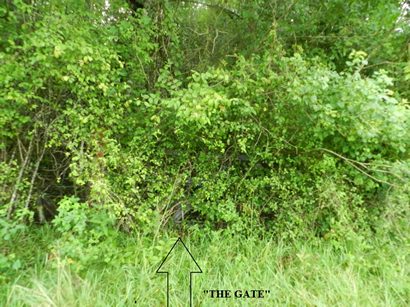
The gate was where the pipeline entered Big Thicket. I knew approximately
where the gate was supposed to be, but as I walked up and down the
fence line, I could not see anything that looked like a gate. Finally,
I saw one piece of the metal gate that had not been completely covered
by the foliage. The way that gate was over grown, it could not have
been opened in the last 25 years. It was now a little after 5 o'clock
in the afternoon as I approached the gate to enter Big Thicket. I
had a little more than three hours of daylight left. |
 |
|
Literally, as
I stood looking at the gate, about to climb into The Big Thicket,
my phone rang. It was the grandson wanting to know how my day was
going and if we could still go to his marker that afternoon. Here
I was at the very spot I had been wanting to be for five years.
Should I climb the fence to see the James B. Woods marker or turn
around and go see his marker? Of course, I wanted to do both. The
reader can decide the best answer to that question after reading
the next few paragraphs.
Back at my breakdown, once I called to cancel our appointment, it
just never occurred to me to try to re-schedule that same day and
just assumed he would have been too busy for that. I told him that
I wouldn't have time that afternoon, but what about tomorrow? He
said he was completely booked up on Friday. I felt bad but the gate
was right in front of me. And the marker was somewhere past that
gate. I fully believe the timing of that call was Providential.
The choice was up to me. I was all ready. What could go wrong?
Most forested areas are commonly quite hilly. Big Thicket is almost
totally flat. Looking at the overhead photos of the area, I commented
to one person that I should be able to walk there in fifteen minutes
or so. He just shrugged his shoulders and said I needed to take
a shot gun and a machete. What could he have meant by that? I climbed
over the gate and started in. With the coordinates in my GPS, I
simply needed to walk straight to my destination, but, in any wooded
area you can't walk straight any where. Big Thicket is not just
any wooded area. There were vines, fallen timber and low hanging
branches and spiders with huge webs. Those familiar with Texas spiders
know that any time one branch is near another branch, a spider has
a web between them. These were huge webs, maybe three feet across
with huge spiders. I picked up a stick and tried to clear each web,
but there were too many. They were unavoidable.
The Big Thicket, as could be expected, is "Texas Big." It encompasses
more than three million acres in nearly 30 counties. Anyone can
visit The Big
Thicket National Preserve with over 100,000 acres of protected
land and water ways. You can watch a 15 minute video in the comfort
of air conditioned surroundings telling you all about its birds,
animals, flora and fauna. It has nearly 40 miles of wide, paved
hiking trails. But I wasn't in Big Thicket National Preserve. I
was in Big Thicket as it really was.
Here was a native born New Mexican who grew up being able to see
Guadalupe Peak over sixty
miles away. Now visibility was hardly more that 40 feet or so in
any direction, and every direction looked exactly the same. Just
going in the general right direction was a challenge. And those
spiders! It wasn't particularly hot or humid, and I wasn't sweating
much, but I was soaking wet. All those leaves and branches were
dripping wet, from what, I don't know. My map and the papers in
my pocket had all turned to a mass of pulp. There was no way to
keep my glasses clear. My vision was the same looking through them
or over them.
Because the sky was slightly overcast, there were no discernible
shadows. There was absolutely no way to keep from being totally
disoriented. Most people have been lost at some point. It might
just be looking for your car in a huge parking lot where most of
the cars look just like yours, or lost in a multi-story office building
where every office is the same or lost in a wilderness. Without
my GPS, I was lost. But I just kept going, keeping, the best I could,
headed toward the marker. After maybe 45 minutes or so, it dawned
on me the kind of situation I had gotten myself into. I could tell
my GPS battery was getting low and my backup GPS wouldn't be much
better. My guess is that I was within 50-75 feet of the marker.
It might have taken me maybe 10-15 minutes to locate it, but I decided
in an instant, not to use that 15 minutes looking for it.
Being within just a few feet from the marker, I turned around and
headed back toward my truck. Which, I think, was less than one-half
mile away. After a few minutes, I was well over one-half mile away!
That is how confused I had gotten. From the scribbled coordinates
written on my pulpy paper, I may have actually circled the marker
without seeing it. By now I could tell I was getting very tired.
That is when I started to notice the vines with all those thorns
and thistles. I must have been much more careful going in, but was
getting very careless now. The thorns and thistles did a real number
on both my arms and hands. Without those canvas chaps, my pants
would have been in shreds. And those spider webs! My head and arms
were covered with them. Sitting down on fallen logs for just a few
minutes was a great help to regain some of my composure. I did that
two or three times and felt much better. Really concentrating on
what I was doing, the distance began to decrease.
That was when my GPS battery gave out. Now I was down to using my
less reliable backup. Would it hold up? Still with no sense of direction,
I kept plodding on. By now, that is what I was doing, plodding through
those thorny vines and spider webs. Then I began to hear sounds
of civilization. It is amazing, with no orientation, how sound can
be so directional. Soon, walking toward the sound, I came to the
fence; thoroughly, totally, absolutely exhausted and soaking wet,
with just minutes left of daylight. There were a lot of "What Ifs"
racing through my mind. Am I sorry I didn't find that marker? Absolutely
not. I have not seen the James B. Woods marker, but I know someone
who has. That's good enough for me.
Thankful to be out of Big Thicket in one piece, without a single
spider bite, mosquito bite or snake bite, I returned my borrowed
chaps and gladly headed for my reserved room down at the Baytown
Super 8 on Interstate 10. You can only imagine how good that long,
hot shower felt that night. Even though I slept well, the events
of the day were racing through my mind all night long. I was ready
to head for home but there was a lot of trip left on my itinerary.
|
 |
"The Boeing
747 Space Shuttle Transports with a full sized replica Shuttle mounted
on its back."
Barclay
Gibson July 2016 photo |
Though I had
planned extra time for Friday, by the time I had breakfast (I had
only eaten one apple and one orange since my Petro Truck Stop breakfast
the morning before), packed and re-oriented myself a little, it was
time to get through Houston
before the weekend traffic hit. Still healing from my Big Thicket
wounds, on the way, I wanted to stop by the Johnson Space Center to
see the recently installed exhibit featuring one of the actual Boeing
747 Space Shuttle Transports with a full sized replica Shuttle mounted
on its back. That was a sight to see.
I got around Houston with
no problem. Even then I dodged a big one. With moderate traffic on
Loop 610, I had cars in both lanes beside me. Suddenly, just in front
of me, I saw a scoop shovel right in the center of my lane. With no
time or space to dodge either way, I straddled it without touching
it. I don't know about the car behind me. If that shovel became airborne,
it could have sliced right through a windshield. I couldn't see anything
unusual so maybe it made it to the side of the roadway without doing
any harm.
My
next stop was Fort
Bend County. Having already seen all of the Centennials in the
county, there were two that had been moved to better settings. One
was for the site of the original fort at the bend of the Brazos River,
hence the name of the county. It had been re-set on one of the walking
trails in the beautiful new County Sheriff Complex on the Brazos River.
The other for Randal Jones was now located next to the nicely restored
former Fort Bend County Jail which now houses the Richmond City Police
Department. |
 |
In all my
Texas travels, I've had more than my share of really bad motel
rooms. Arriving in Wharton,
I made my way to one of my favorite stop overs, the Tee
Pee Motel. Originally built in the 1940's, there are ten individual
"tee pee" units which have been updated in the last fifteen years
or so. Each consists of a small, circular room with only enough space
for one bed, a couch and a bathroom. What I had been looking forward
to all day was a delicious Mexican food meal at Los Cucos overlooking
the Colorado River. Purposely not eating anything since breakfast,
I still couldn't eat it all. For me, a meal at Los Cucos in Wharton
is beyond description.
Saturday was going to be another complicated day. After breakfast
at Denny's, I headed to Kerrville.
Trying to explain why Kerrville
was my destination is even more complicated. As mentioned at the very
beginning of this tale, I had begun planning this trip over a year
ago. The final date was set several months ago for me to spend a day
in Athens, the day
after our friend's move, Monday, July 25th, next day to see Gerald,
then the Woods marker, then Wharton.
From Wharton, my next appointment
was northwest of Mertzon
in Irion County, 430 miles away.
My wife and I have some very good friends, Pat and Katie, who a few
years ago, retired and built a house near Kerrville.
The first part of June, Pat died suddenly of a massive stroke. His
memorial service was scheduled at their house near Kerrville
on Saturday evening, July 30st. For months, my schedule, set by our
friend's move to Athens,
had me to be passing through Kerrville
on Saturday, July 30th, the day of Pat's memorial service! |
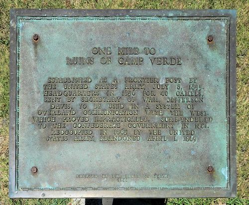 |
"One Mile
to Ruins of Camp Verde" Centennial plaque
Barclay
Gibson July 2016 photo |
But there's more.
Just weeks before I was set to leave from Oregon, a fellow marker
hunter, Greg, found an un-inventoried Centennial plaque, just like
the ones that were in Nacogdoches.
This plaque is located at Camp
Verde commemorating the imported camel experiment that took place
there just before the Civil War. Camp
Verde is located just south of Kerrville,
barely ten miles out of my way. Greg and I have both coordinated our
Centennial efforts through Sarah
Reveley, who lives in San
Antonio. She wanted to see the newly found Camp Verde marker,
too.
Originally I would meet her and her sister-in-law at Camp
Verde. But due to some last minute scheduling glitch, her sister-in-law
would drive ahead, if I could pick Sarah up at her house, barely an
hour's drive from Camp
Verde. The timing worked out beautifully. We met at Camp
Verde at about 11 o'clock and saw plaque after having lunch at
the very nice restaurant at Camp
Verde. While having lunch, Sarah happened to mention that the
Reeves County Centennial Pope's Crossing marker north of Pecos
had been knocked over by an oil truck making too sharp a turn. Sarah
was trying to figure out who to contact about having it re-set in
a more protected enclosure. Later, checking my route to Carlsbad from
my last maker appointment, I saw that changing my route to go through
Pecos was only
four miles further. Done deal.
After they left to go back to San
Antonio, I had time on my hands until the memorial service at
6:30 Saturday evening. That time was well spent at the very quiet,
air conditioned Kerrville Library, where I could relax and do a little
reading while trying to stay awake until time for the service that
evening. The very respectful service was a short walk from their house
under a grove of Hill
Country live oaks. All of their family; kids, and grand kids,
had a part. Their son, a preacher with a church in Florida, did the
eulogy.
My room that night was in Junction,
about an hour west on I-10. My appointment for my next marker was
to meet at the ranch headquarters northwest of Mertzon
at 9:00 o'clock. From there one of the owners drove me over bouncy
dirt roads to the Centennial Coughlin's Stage Stand marker near a
tributary to the Concho River. After that, I was on my way to Pecos
to see the condition of the Pope's Crossing marker. On my arrival,
I was pleased to see that it had already been repaired having been
placed in a nice concrete base with four big posts now protecting
it. Sarah would be pleased. |
 |
|
So that's about
it. I got to see three of the markers and got very close to the
forth (giving myself � credit for my attempt). Plus the extra one
at Camp
Verde. As I said from the beginning, it was my most exciting
and unusual trip. And it turned out to be the most complex. I'm
still wondering how different this trip might have been had I thought
to re-schedule my 2:00 o'clock appointment? That is one of the "What
Ifs" I'll never know the answer to. At least I now had a few days
in Carlsbad to unwind before heading back to Oregon.
© Barclay
Gibson,
September 9, 2016 Column
Related Topics:
Texas Towns | Texas
Counties | Texas Trips |
Texas
|
|
|