|
|
Ghost Counties
of Texas
Remembered
today only by yellowed state records,
brittle maps, and faded postmarks
An incomplete list illustrated by maps
courtesy of the Texas General Land Office. |
Texas Ghost Counties:
Buchel and Foley, T & P map
Courtesy of the Texas General Land Office |
Buchel and
Foley Counties
Buchel
and Foley County were both formed in March of 1887 from Presidio County.
They were born together and both were annexed to Brewster County in
1897. A bill was passed to dissolve the counties, but Governor Charles
Culberson never signed the papers. Nevertheless, the bill passed without
the governor�s signature and the two counties were absorbed by Brewster
County; making it the largest county in Texas. Marathon,
Texas was to have been the county seat for Buchel County.
The namesake of the proposed Buchel County was Augustus Carl Buchel
� a soldier�s soldier. Born in Hesse, Buchel served in the French
Foreign Legion and later as a Colonel in the Turkish Army. He came
to Texas via Indianola
and during the Mexican War served on Taylor�s staff. In the Civil
War he was a Lt. Col. Of Texas Infantry and later served as a full
Colonel in command of the 1st Texas Cavalry. He was killed at the
battle of Pleasant Hill, Louisiana in 1864 and his body was later
interred at the Texas
State Cemetery in Austin.
|
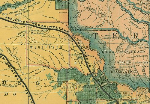 |
Texas Ghost Counties:
Wegefarth and Greer - 1876 RR Map
Courtesy of the Texas General Land Office |
Wegefarth County
Wegefarth County,
which came into being on June 2, 1873 only lasted a brief three years.
It was erased from state maps in August of 1876 when the huge lands
of Bexar County were broken into the familiar square counties of the
upper Panhandle. The unfamiliar surname comes from the president of
the Texas Immigrant Aid and Supply Company � a man known as C. Wegefarth.
|
Greer County
Greer County, Texas
has since become Greer County, Oklahoma. If left on the state map,
this county would�ve distorted the now-familiar silhouette of Texas.
Formed just prior to the Civil War, it remained on maps until the
U.S. Supreme Court made the separation official in an 1896 ruling.
|
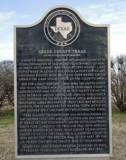 |
Historical Marker:
Greer
County, Texas
Created 1860; until
1896, one of largest counties in Texas. Organized at Old
Mobeetie, northwest of here. In 1880s settlement was rapid; by
1892 nearly 2,500 pupils were in county's schools. A post office,
jail and many houses were built, and over 60,000 cattle grazed the
3,480 square miles of the county's area.
But for a half-century (1846-1896) the United States and Texas waged
a heated dispute over Greer County. Controversy had origin in an 1819
treaty fixing the line between United States and Spanish territory.
A map designating the Red River and 100th meridian as boundary lines
was part of treaty; but map aroused dispute, for it incorrectly marked
100th meridian and showed only one fork of two-forked Red River.
Texas claimed the North Fork and meridian shown on map defined territory,
and legislation and occupancy by Texans decided sovereignty. United
States contended South Fork (larger of the two) and true 100th meridian
marked boundaries. Three joint survey commissions failed to settle
the issue. The U.S. Supreme Court in 1896 ruled that the region was
in 1819 part of the Union and thus, was actually part of Oklahoma.
Named for John A. Greer, Senator, Secretary of State, Republic of
Texas; Lieutenant Governor, 1847-1853.
[See Greer County
by Mike Cox] |
 |
Texas Ghost County:
Encinal
Courtesy of the Texas General Land Office |
Encinal County
Encinal County
was formed in 1856 but was never formally organized. The present-day
town of Encinal was to have been the county seat of government. The
county was officially removed from documents on March 12, 1899. |
Perdido County
The appropriately-named
Perdido (Lost) County came into being in the 1820s � prior to the
Texas Revolution. During the post-revolution land grants and the confusion
of the 1830s and 1840s, the county was forgotten. With hardly any
population to complain to Austin,
it was thought to be abolished in 1858. After the turmoil of the Civil
War, Perdido surfaced again � and was officially declared dead in
1871.
In 1848 land east of the Rio Grande was ceded by Mexico
to form Santa Fe County. It disappeared with the Compromise of 1850.
|
Worth
County
Worth County was originally formed from part of New Mexico�s Santa
Fe County on the third of January 1850. Although Val Verde was to
be the seat of government, the county was never organized and the
Compromise of 1850 ceded the land to the United States. |
The First
Dawson County
Prior to the formation of the current Dawson
County in the Panhandle
in 1876, there was a previous Dawson County (established on February
1, 1858) just west of the Texas
Hill Country. Erased from maps by acts passed on October 5th,
1866, the county was formed by parts of western Uvalde
County and part of eastern Kinney
County. Named for Nicholas Dawson, this county was simply added
to the Uvalde and Kinney
County boundaries. |
 |
Historical Marker:
Texas Territorial
Compromise of 1850
Four miles east
of this site is an official corner post marking agreement of Texas
to give up some of the land won in her 1836 war for independence.
It also marks New Mexico's southeast corner. When Texas
was annexed to the United States, 1846, her territory included 98,300
square miles now in the states of Colorado, Kansas, New Mexico, Oklahoma
and Wyoming. After the Mexican War (fought 1846-1848, over the annexation),
anti-slavery forces in the U. S. sought to trim the size of Texas,
a slave state. To raise money and establish a definite boundary, Texas
accepted the compromise of 1850 and agreed to give up a third of her
area in return for payment of $10,000,000. The money paid debts of
the former Republic of Texas, set up a $2,000,000 public school fund,
and erected state buildings, including a new capitol (which subsequently
burned in 1881). By the 1850 compromise, the western boundary of Texas
follows the 103rd meridian south from 36* 30'; near here intersects
the 32nd parallel, then goes west along the parallel to the Rio Grande.
The corner marks not only a peaceable boundary pact, but also shows
an unbroken stretch of Permian Basin lands, unified in geography and
common goals. |
| Texas
Escapes, in its purpose to preserve historic, endangered and vanishing
Texas, asks that anyone wishing to share their local history
and vintage/historic photos, please contact
us. |
|
|