Books by
Michael Barr
Order Here: |
|
|
The
Pinta Trail began as a natural footpath for Native Americans traveling
through the Hill
Country. First used in the 17th century, it is one of the oldest
paths followed by humans in this part of the world.
In the 1750s, Spanish priests and soldiers traveled the Pinta Trail
from their base in San
Antonio to the San
Saba mission and presidio near present-day Menard.
When the German Texans came up from Indianola,
they followed sections of the Pinta Trail into the relatively uncharted
Hill Country.
Surveyors, rangers, teamsters, and adventurers used the Pinta Trail.
Jim Bowie followed it in search of the lost San Saba mine.
After the U. S. Army built Fort
Martin Scott and later Fort
Mason, the Pinta Trail became an army supply route from San
Antonio to the western outposts.
And when surveyors laid out a stagecoach road from San
Antonio to El
Paso, the path generally followed the Pinta Trail through the
Hill Country.
The
trail's original location was no accident. When the Plains Indians
traveled, they usually followed the buffalo.
They knew the buffalo
instinctively followed the easiest grades with the lowest mountain
passes and the best low water crossings.
The origin of the name "Pinta" is steeped in legend, and like so
many place names in Texas, it has been garbled by centuries of misspellings
and mispronunciations in several languages. Pinta may be a derivative
of "pinto," the distinctive color patterns of the Indian pinto ponies.
The Pinta Trail was not always a single narrow path but was often
comprised of several branches that ran in the same general direction.
The width of the trail ranged from a few feet to several miles.
And the location was not constant. Sometimes events of nature like
floods and landslides caused the trail to shift.
|
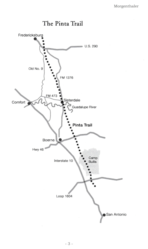 |
The Pinta Trail
Used with permission of Jefferson Morganthaler, from his book The
Pinta Trail. |
|
Although
the exact route is often vague, the Pinta Trail ran from the missions
on the San Antonio River, to Leon
Springs, to just east of Boerne.
From there the path ran northwest, passing near Sisterdale
and then crossing South Grape Creek near Grapetown.
After that the trail swung through the pass at Cain
City, crossing the Pedernales
River at the bend just east of the mouth of Baron's Creek, a
mile south of Fort
Martin Scott .
B. L. Enderle, Gillespie
County teacher and surveyor, was a student of the Pinta Trail,
and he believed the ancient road took two paths out of Fredericksburg.
One path went to Cherry
Spring and Loyal
Valley, crossing the Llano
River near Hedwig's
Hill, and on to Mason.
The other branch went in the direction of Bear Mountain and into
Crabapple Canyon before crossing Sandy Creek near Enchanted
Rock. The trail then curved back to the northwest towards Mason.
|
 |
|
Travel
along the Pinta Trail could be hazardous. In June 1844 Captain
Jack Hays and a group of 14 Texas Rangers that included Ad Gillespie,
Ben McCulloch, and Sam
Walker fought a pitched battle with Chief Yellow Wolf and 80
Comanche warriors near the Guadalupe Crossing on the Pinta Trail.
The Rangers were heavily outnumbered, but they had a huge technological
advantage. It was the first time an entire company of Rangers used
Colt
revolvers in combat.
The battle raged for hours, but after Gillespie dropped Yellow Wolf
with a rifle shot, the remaining Comanches retreated to the northwest.
Although
most visible signs of the Pinta Trail have vanished, many modern
roads and highways follow parts of the old route. The Northwest
Military Highway out of San
Antonio, Interstate 10 between San
Antonio and Boerne,
Highway 87 between Fredericksburg
and Mason,
Ranch Road 965 from Fredericksburg to Enchanted
Rock, and Highway 29 from Mason
to Menard,
generally follow segments of the old Pinta Trail.
And it was no coincidence that the railroad from San
Antonio to Fredericksburg
followed stretches of the Pinta Trail. After all the buffalo and
the Indians had already plotted the course, and they did it without
a transit or an engineering degree.
|
Sources:
Fredericksburg Standard, April 28, 1971, "Enchanted Rock,"
p5, c2.
Mason County News, February 5, 1976, "Mason County Roundup,"
p9.
Jefferson Morganthaler, The Pinta Trail (Boerne: Mockingbird
Books, 2015).
See also
Texas
Trips
Texas
Hill Country
|
|
|
|


