|
UNCONVENTIONAL
TEXAS TRAVEL
Trips, Destinations and Travelogues
|
Go where few
have gone before:
|
|
|
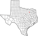
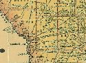
Larissa
1-22-20
Cherokee County Ghost town
Site of the Killough Massacre
|
|
|
Out
of My Shell at South Padre by Jase Graves 7-15-17
"[W]hen my family and I were on vacation at South Padre Island
recently, I jumped at the chance to witness a release of newly hatched
Kemp's ridley sea turtles...."
|
|
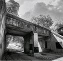
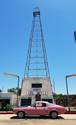
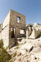
Mariscal
Mine 5-5-17
Photos courtesy Abdul Khan & Erik Whetstone
"Deep inside" Big Bend National Park on Mariscal Mountain. A National
Register Historic District.
|
Out-of-the-way
places by Bob Bowman
A friend once told me his greatest pleasure was driving around East
Texas and looking for oddball places seldom found in tourism brochures...
From
Bugs Bunny to Sam Houston by Clay Coppedge 1-5-14
If you're the type of motorist who doesn't mind stopping every few
miles to read a brief tidbit of history by the side of the road
you can put together a pretty fair sketchbook of Texas history just
from the historical markers scattered all over the state... more
Recollections
of a Road Trip to West Texas by Ana Astri-O�Reilly 2-1-14
|
|
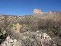
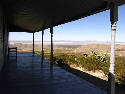
Williams
Ranch by Barclay Gibson 6-3-13
Guadalupe Mountains National Park
Culberson County
|
|
|
Ignoring
Warning Signs by Barclay Gibson 10-1-10
Searching for the �Buried Here�1936 Texas Centennial marker
�Warren Wagon Train Massacre�
|
|
|
Searching
for the Pulaski Historical Marker by Barclay Gibson 9-6-10
Where to start describing how I visited the five foot tall granite
1936 Panola County Centennial Historical Marker for the defunct
town site of Pulaski, former seat of Panola County?
|
Prada
Marfa by Luke Warm
West Texas gets a Long-overdue Infusion of Whimsey by German-based
Artists
Photos Courtesy Lizette Kapre, Ballroom Marfa, & the Art Production
Fund
|
|
|
The
Roads of Upshur County by Bob Bowman
Most East Texas counties name their county roads with numbers or
the names of people. But not Upshur County. Years ago county officials
came up with the unique idea of naming one precinct of the county�s
roads for animals, another for flowers, still another for trees
and the fourth precinct for birds....
|
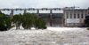
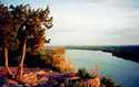
Highland
Lakes and Dams by Rob Hafernik
Dams: Tom Miller Dam, Mansfield Dam, Max Starke Dam, Wirtz
Dam, Inks Dam and Buchanan Dam
Lakes: Lake Austin, Lake Travis, Lake Marble Falls, Lake
LBJ, Inks lake, and Lake Buchanan
|
|
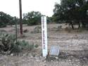
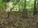
Finding
the Polancio Grave Marker by Barclay Gibson
Back in the 1870s a stage was attacked by Indians and a man, Jose
Maria Palacios, was killed. He was buried right where he fell, at
the base of the Peak and a crude rock slab had the information scratched
on it...
|
|
Last
Remaining International Boundary for The Republic of Texas
by Gerald Massey 2-21-09
Texas' shortest
highway - SH 165 that runs through the State
Cemetery in Austin
Road
Log 1922 by Mike Cox
A daily log kept by James A. Correll in the late spring and summer
of 1922 shows it's a little easier to get across Texas than it used
to be...
Dead
Man's Hole by Mike Cox "Texas Tales''
The expression "he just dropped out of sight" had both figurative
and literal meaning in Burnet County during and after the Civil
War. Common belief held that folks who disappeared in that area
often ended up at the bottom of a 150-plus-deep foot limestone fissure
south of Marble Falls aptly named "Dead Man's Hole."
East
Texas' Burning House by Bob Bowman
Motorists traveling along U.S. Highway 59 in Polk County are often
startled to see what appears to be flames pouring from the windows
of old sawmill house...
Nameless
Cave by Mike Cox
"It figures that the cave in this story � one of an estimated
6,000 caverns in the limestone region of the state � doesn�t have
a name. After all, it�s in the vicinity of Nameless, Texas...."
The
McDow Hole by Bob Hopkins
"The story of the McDow ghost became very popular by the end
of the 19th century ... many people would come to the water hole
hoping to get a glimpse of the specter."
TUMBLEWEEDS'
TALES
Ghost Towns and Town Ghosts by Stephen Osmon
�When you get there you�ll know. Then you will have to decide, will
you stop or will you pass by? It could change your life forever;
but you gotta make the first move....�
|
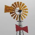
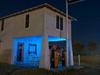
Midday
at the Oasis by Johnny Stucco
Photos by Erik Whetstone
"Having never pumped a pint, let alone a gallon of gasoline,
this station-that-never-was has become our symbol for a particular
period in Texas history."
|
|
Taken
on the Road by Charles Kuralt by James Feagin
Early 1986, my parents had returned from their weekly rounds to
the local bookstore in Columbia, Maryland. Sifting through their
variety of books, I came across a title that would change my young
life, �On the Road with Charles Kuralt.�...
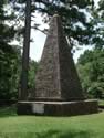
A
Unique Landmark by Bob Bowman
A granite shaft set into the ground on April 23, 1841, marks the
only international boundary existing within the continental United
States.
Farm Road 31 between Deadwood, Texas, and Logansport, Louisiana
The
Ark-La-Tex by N. Ray Maxie
The Ark-La-Tex includes Three Corners, the place where three state
lines meet, and portions of Arkansas, Louisiana and Texas. Many
... have done the "spread eagle" there, especially area high school
kids. Reportedly there are hordes of people that have traveled many
miles to do just that.
Loop
168, the shortest highway in Texas
Los
Ebanos and the last hand-operated ferry on the Rio Grande
Lover's
Leaps by Mike Cox
Texas' four landmarks known as Lover's Leaps ...
Texas
War Casualties by John Troesser
Delhi, Smithville and Praha. Stone markers and chapels quietly reveal
where America gets its soldiers.
Stuff
To Do in Small Towns by Maggie Van Ostrand
Route
66 in Texas - The towns found along Texas 66 and their museums,
ghost towns, relics, markers and monuments.
The
Crash at Crush by Luke Warm
The field that once was Crush, Texas is now occupied by cows, but
a recently replaced historical marker south of West, Texas tells
the story of one of the most bizarre publicity stunts of all time.
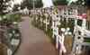
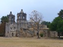
The
Painted Churches Tour - The painted churches of Fayette County
Lost
Towns of the Pecos - Arno, Orla, Portersville and Verhalen
"The
Eight Corners of Texas: A Guide to Visiting Some of Texas' Least
Frequented and Known-about Areas - The Exact Corners" by
Paul McBurnett
The
Texas State Railroad and Texas Forest Trail by John Troesser
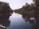
Canoeists
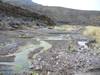
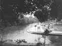
Take On Pristine Texas River by Sandra Billingsley
Article originally published on July 15, 2001 in the San Angelo
Standard-Times. Photographs courtesy of Sandra R. Billingsley and
Robert A. Phillips.
A
Flatboat Named Enchilada - Crossing the Rio Grande at Boquillas
Woman
Hollering Creek
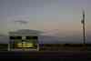
The
Oasis Gas Station
The
Iron Road Sorority: Penelope, May, Pearl, and Venus
Ghost
Towns 101 or How to Survive a Ghost Town Visit
Ten
Counties You're Not Likely to Visit
But you'll miss the Ruffini Courthouse and the pictographs.
|
|
|